Elevation of Dolphin Isle, Foster City, CA, USA

Location: United States > California > San Mateo County > Foster City >

Longitude: -122.25559

Latitude: 37.5604502

Elevation: 2m / 7feet

Barometric Pressure: 101KPa

Elevation Map:

elevation map of Dolphin Isle, Foster City, CA, USA

Satellite Map:

Satellite map of Dolphin Isle, Foster City, CA, USA

Related Photos:

sanmateobridge sr92 coyotepointpark burlingame california sanmateo–haywardbridge longexposure dusk seascape bay ngc bayarea wave ocean shore seaside coast westcoast pacificocean landscape outdoor clouds sky water rock mountain rollinghills sea sand beach cliff nature wetlands evening nightphotography nightscene bridge
Night Bridge and Its Reflections
lighttrails sanfranciscointernationalairport millbrae sanfrancisco lowfog foginsf cityscape longexposure dusk seascape bay ngc bayarea wave ocean shore seaside coast california landscape outdoor clouds sky water nightphotography nightscene traffictrails
Flew into the Night Clouds
sfo longexposure dusk california sky evening nightphotography nightscene traffictrails traillights airplane aircraft house sanfranciscointernationalairport airport
SFO’s Saturday Night
trafficlighttrails lighttrails interstate280 route92 sanmateo lowfog foginsf longexposure dusk seascape bay ngc bayarea wave ocean shore seaside coast california landscape outdoor clouds sky mountain rollinghills evening sunset traffictrails summer
On Their Way Home
sanfranciscoskyline sealpoint sanmateo northerncalifornia sanfrancisco cityscape dusk seascape bay ngc bayarea wave ocean shore seaside coast california westcoast pacificocean landscape outdoor clouds sky water rock mountain rollinghills sea sand beach cliff architecture building baybridge
San Francisco Skyline in the Far Distance
aerialphotograph nikkor nature paloaltoairport paloaltomunicipalgolfcourse duckpond baylandsnatureinterpretivecenter sanfranciscobay santaclaracounty sanmateocounty california eastpaloalto sanfrancisquitocreek paloalto aerial
Aerial view of Palo Alto Airport, Palo Alto Municipal Golf Course, the duck pond, the Baylands Nature Interpretive Center, and San Francisco Bay, Palo Alto, Santa Clara and San Mateo Counties, California.
yellowrumpedwarbler warbler setophagacoronata 1stwinter coyotehills coyotehillspark 1stwinterbird bird passerinebird passerine passeriformes fremont california ca canon7dii sp167 donedwardsnationalwildliferefuge myrtlewarbler
Yellow-rumped Warbler (Setophaga coronata) (sp. # 167)
starling commonstarling europeanstarling sturnusvulgaris sturnus vulgaris edenlandingecologicalreserve edenlanding edenshorespark edenshore unioncity california bird perched nature blue sky sp201
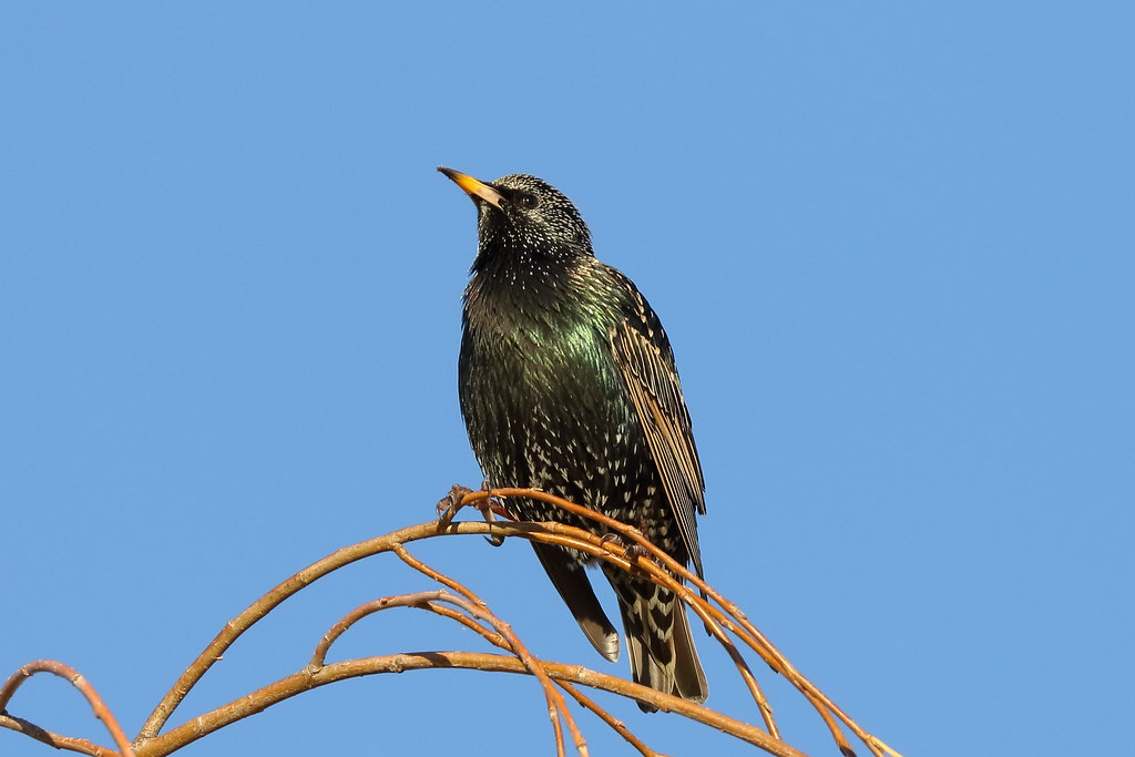
Common Starling / European Starling (Sturnus vulgaris) (adult) (sp. # 201)
fog cloud atmosphere weather upslopefog watervapor ground forest mountain droplets nature risingterrain marvel outdoor tree sky mist
Upslope Fog
bw portrait alone incomplete seeing window view flickrfriday self
Do you see me?
whitetailedkite whitetailed kite raptor bird birdinflight birdofprey elanus leucurus elanusleucurus coyotehills coyotehillspark fremont california juvenilebird juvenile sp186 blue bluesky sky
White-tailed Kite (Elanus leucurus) (sp. # 186)
eiaiisraelairlines 4xerb boeing787 boeing7878dreamliner sanfranciscosfo sfooutdoorterrace sfo skyterrace telaviv hodhasharon
4X-ERB
california bridge winter sunset panorama color water silhouette reflections bay nikon track view over january large rail panoramic southbay eastpaloalto stitched d800 dumbartonbridge 2015 boury pbo31 patrickboury
the gatekeeper
menlopark california usa bedwellbayfrontpark siliconvalley sanfranciscobay sanfranciscobayarea redwoodcity redwoodshores sanmateo sanmateobridge bridge house dusk goldenhour night outdoor water saltflat saltpond sony a6000 sel55210 1xp raw photomatix hdr qualityhdr qualityhdrphotography fav100
Waiting for darkness
california road bw northerncalifornia yellow landscape fav50 stripe fav20 norcal asphalt fav30 median hdr highdynamicrange lonetree pf selectivecolor lowperspective goldenstate middleoftheroad 1000v fav10 fav100 tonemapping fav40 fav60 fav90 fav80 fav70 elmofoto lorenzomontezemolo forcurators
you're either shooting or you're dead v2.0 {+1 in comments}
stanford paloalto california siliconvalley usa sanfranciscobay sanfranciscobayarea southbay stanfordhospital stanforduniversity architecture room waitingroom doctoroffice office indoor symmetry sony sonya7 a7 a7ii a7mii alpha7mii ilce7m2 fullframe vintagelens dreamlens canon50mmf095 canon 1xp raw photomatix hdr qualityhdr qualityhdrphotography fav100 hospital
New Stanford Hospital: $2 billion view
sanfranciscointernationalairport sfo jet travel visit plane tickets airport vacation firstclass miles aviation corporate terminal runway landing takeoff approach tourism commute airtravel ksfo bayarea sanmateocounty fineart aerialview aerialphotographer blackandwhite helicopter commercial realestate signatureflightsupport logistics operations 94128 12297662992 sanfrancisco california unitedstates flight fly
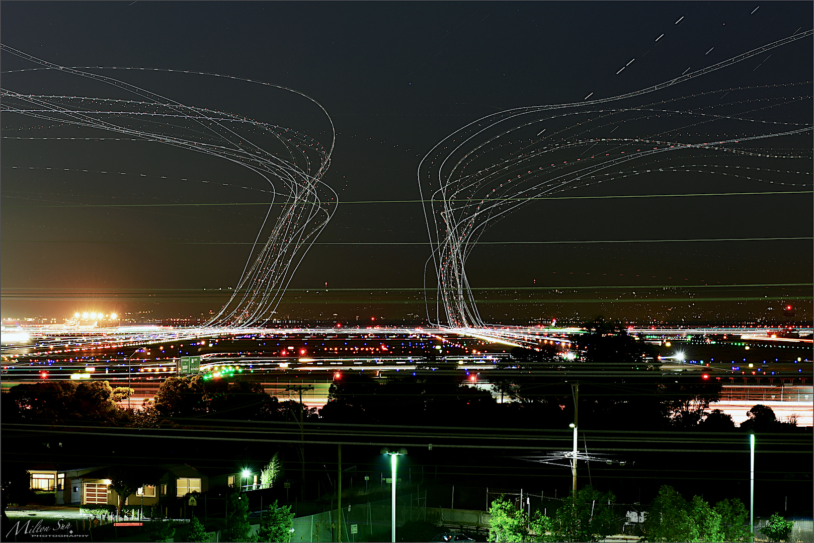
San Francisco International Airport Aerial View
life trees bw fog freedom thistle horns sharp barb barbed captivity mencken selectivecolor oscillation worldbest excellentphotographerawards
oscillation between the sharp horns of dilemmas
sealpoint sanmateo transmissiontowers dusk bay bayarea wave ocean shore seaside coast westcoast landscape outdoor clouds sky water sea sand beach evening sunset hills gittersteigen gittersteiger
Transmission Towers at Dusk
morning trees blackandwhite bw white mist black silhouette fog foggy bayarea onthewaytowork drivebyshooting bwdreams intooblivion reallyfoggy ysplix idisappear top20grey onlyhad5minutestogetsomequickshots cantresistfog sucksmein
folds of oblivion
bushtit psaltriparusminimus psaltriparus minimus songbird edenlandingecologicalreserve edenlanding edenshore unioncity california donedwardsnwr donedwardsnationalwildliferefuge bird americanbushtit passerinebird passerine edenshorespark hayward
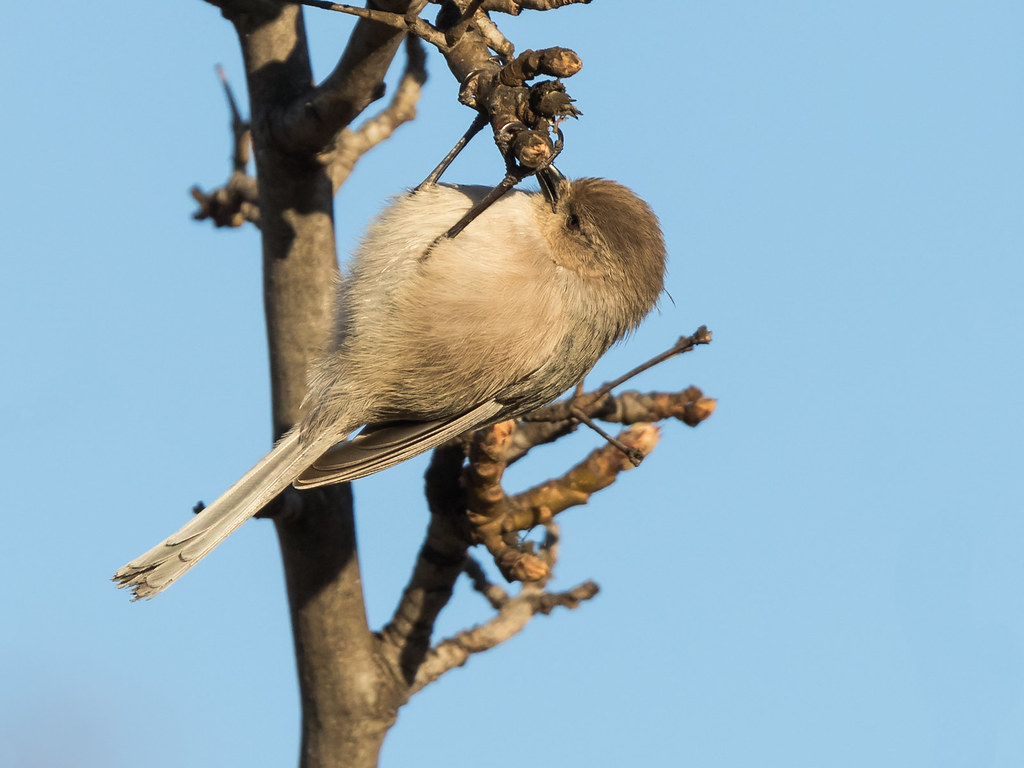
Bushtit / American Bushtit (Psaltriparus minimus) (sp. # 182)
pier oysterpoint southsanfrancisco california bridge longexposure seascape bay ngc bayarea wave ocean shore seaside coast landscape outdoor clouds sky water rock sea sand beach
A Small Pier on the Bay
california canon5dmarkiii canonef24105mmf4lisusm clouds edgewoodpreserve landscape lightroom5 muledeer sanmateocounty topazsw
A Cloudy Day
ebparksok
Hayward Regional Shoreline
unitedairlines united n2142u n2138u boeing777 boeing777300 boeing777300er boeing777322er boeing 777 777300 777300er 777322er b77w ksfo sfo sanfranciscointernationalairport sanfranciscoairport sanfrancisco
Boeing 777-322/ER face off at SFO
city bridge storm water rain clouds bay harbor san francisco power cloudy gray explore rainy rainstorm redwood pylons explored day29366 29jan16 366the2016edition 3662016 4b4a9329
29/2016 - The Redwood City Weather Forecast
spotting ksfo canon plane aviation
Singapore Airlines Airbus A350-941 9V-SMP
spotting ksfo canon plane aviation
Lufthansa Airbus A380-841 D-AIMF
menlopark california unitedstates oldfashioned flickrfriday
20180908-DSCF4428
ca flower field clouds landscape cloudy hill bluesky fremont hills sanfranciscobayarea greenery eastbay willows coyotehills fremontca eastbayregionalparks cloudseastbay
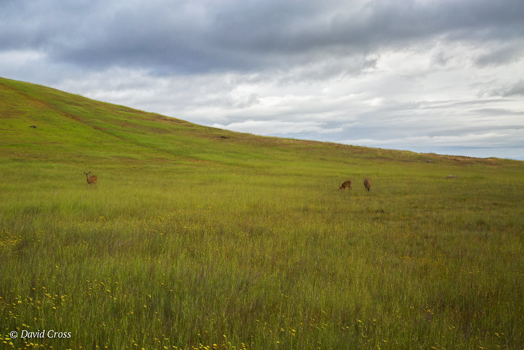
A Spring Day in Coyote Hills
spotting sfo plane aviation canon 5d
Delta Air Lines Boeing 717 N994AT
spotting ksfo canon plane aviation
Emirates Airbus A380-861 A6-EOE
ca california cloud clouds cloudseastbay coyotehills eastbay eastbayregionalparks fremontca landscape marsh marshland sanfranciscobayarea water wildlife winter
Coyoto Hils Marsh No3
spotting sfo sanfrancisco plane aviation canon
Asiana Airbus A350-941 HL8078
redwoodcity california unitedstates sanmateo sfbayarea sf nikon d800 nikond800 2470mm sunset landscape reservoir tree lonetree marsh wetland crystalsprings fog marinelayer coastalrange fav100 rakesh sharma fav200 fav300 fav400 fav500 fav600 fav700 fav800 fav900 fav1000 50000v
t r a c e s | san mateo, california
california trees orchard olives olivetrees californiacentralcoast filoligardens
Filoli Gardens California-Central-Coast 2015-03-30
leastsandpiper sanleandromarina sanleandro california unitedstates us
Least Sandpiper
sanleandromarina blackphoebe sanleandro california unitedstates us
Black Phoebe
ca california clouds coyotehills eastbayregionalparks fremont fremontca grassland lizardrock pond sunset winter
Lizard Rock Sunset
sf california ca sea orange usa water yellow sunrise landscape dawn bay us san francisco unitedstates tide low over calif mount diablo burlingame millbrae flickrstruereflection1 ilobsterit
Sunrise over Mount Diablo and San Francisco Bay - Millbrae California