Latitude: 37.045586
Longitude: -107.875169
Elevation: 1840 meters / 6037 feet
Barometric Pressure 811KPa

Related Photos

Cox Canyon Arch with Milky Way Core by Mandira2007, The arch sits on a rock shelf or terrace on the side of a hill.
In my head I had debated weather or
Cox Canyon Arch with Milky Way Core by Mandira2007
La Plata Mountains from South of Durango, Colorado by StevenM_61, View is along U.S. Highway 550. Farm machinery in the field.  Photo was taken in 2005.landscape scen
La Plata Mountains from South of Durango, Colorado by StevenM_61
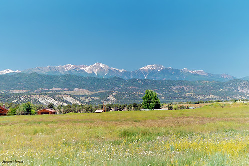
La Plata Mountains from South of Durango, Colorado by StevenM_61, View is by U.S. Highway 550.  Photo was taken in 2005.landscape scenery field meadow mountains mount
La Plata Mountains from South of Durango, Colorado by StevenM_61
U.S. 550 Between Durango, Colorado and Aztec, New Mexico (4) by Ken Lund, Most of U.S. 550 in Colorado is two-lane mountainous highway. It is one of only two north–south U.S.
U.S. 550 Between Durango, Colorado and Aztec, New Mexico (4) by Ken Lund
U.S. 550 Between Durango, Colorado and Aztec, New Mexico (3) by Ken Lund, Most of U.S. 550 in Colorado is two-lane mountainous highway. It is one of only two north–south U.S.
U.S. 550 Between Durango, Colorado and Aztec, New Mexico (3) by Ken Lund
Cox Canyon Arch-1 by Mandira2007, We were surprised at the size of this arch after we climbed up to the rock ledge that supported it.
Cox Canyon Arch-1 by Mandira2007
U.S. 550 Between Durango, Colorado and Aztec, New Mexico (6) by Ken Lund, Most of U.S. 550 in Colorado is two-lane mountainous highway. It is one of only two north–south U.S.
U.S. 550 Between Durango, Colorado and Aztec, New Mexico (6) by Ken Lund
Chimney Rock-John Wayne Country! by Kristal Kraft ~ DenverDwellings, Sunset is a special time a day, no matter where you are in the world.  autumn fall colors colorado a
Chimney Rock-John Wayne Country! by Kristal Kraft ~ DenverDwellings
U.S. 550 Between Durango, Colorado and Aztec, New Mexico by Ken Lund, Most of U.S. 550 in Colorado is two-lane mountainous highway. It is one of only two north–south U.S.
U.S. 550 Between Durango, Colorado and Aztec, New Mexico by Ken Lund
Acequia: Southern Ute Reservation, Colorado (CO) by Floyd Muad'Dib, This part of Colorado is pretty dry, with redrock bluffs beside the Animas River. So an irrigation d
Acequia: Southern Ute Reservation, Colorado (CO) by Floyd Muad'Dib
New Mexico Natural Arch NM-485 by Larry Beck1, Arch Number and Arch Name:  NM-485
Other arch reference numbers:  NABSQNO 13S-235151-4092585
Arch Lo
New Mexico Natural Arch NM-485 by Larry Beck1
Drive By Scenery by W9JIM, Between Farmington, NM and Durango, CO you climb a little grade and get this view.  There's no place
Drive By Scenery by W9JIM
US 550- La Plata County CO (1) by kevystew, Animas Rivercolorado animasriver us550 laplatacounty
US 550- La Plata County CO (1) by kevystew
Petrochem derrick by geophotocacher, - San Juan County, NMjuniperus newmexico landscape derrick rocks nm
Petrochem derrick by geophotocacher
Pathway boulder by geophotocacher, juniperus sandstone newmexico fourcorners landscape flora lichen rocks nm pareidolia
Pathway boulder by geophotocacher
US 550- La Plata County CO (3) by kevystew, colorado animasriver us550 laplatacounty
US 550- La Plata County CO (3) by kevystew
Durango ranch by geophotocacher, ,  on the plateaugrasses mountains architecture landscape flora farmandranch field angiosperm monoco
Durango ranch by geophotocacher
Sedimentary erosion by geophotocacher, - Canyonside, San Juan County, NMjuniperus newmexico fourcorners landscape flora sandstone sanjuanco
Sedimentary erosion by geophotocacher
Rocks and trees by geophotocacher, trees newmexico fourcorners landscape flora sanjuancounty rocks nm
Rocks and trees by geophotocacher
DSC_2614.jpg by krandor, newmexico
DSC_2614.jpg by krandor
IMG_5208 by wwcooper, gps durango amod
IMG_5208 by wwcooper
DSC_3437.jpg by krandor, newmexico
DSC_3437.jpg by krandor
IMG_0693 by Jeremy Heli Photo,
IMG_0693 by Jeremy Heli Photo
DSC_2672.jpg by krandor, newmexico
DSC_2672.jpg by krandor
DSC_2593.jpg by krandor, newmexico
DSC_2593.jpg by krandor
DSC_2651.jpg by krandor, newmexico
DSC_2651.jpg by krandor
DSC_2535.jpg by krandor, newmexico
DSC_2535.jpg by krandor
DSC_2602.jpg by krandor, newmexico
DSC_2602.jpg by krandor
DSC_2667.jpg by krandor, newmexico
DSC_2667.jpg by krandor
DSC_2656.jpg by krandor, newmexico
DSC_2656.jpg by krandor
DSC_2657.jpg by krandor, newmexico
DSC_2657.jpg by krandor
DSC_2568.jpg by krandor, newmexico
DSC_2568.jpg by krandor
DSC_2536.jpg by krandor, newmexico
DSC_2536.jpg by krandor
DSC_2674.jpg by krandor, newmexico
DSC_2674.jpg by krandor
DSC_2655.jpg by krandor, newmexico
DSC_2655.jpg by krandor
DSC_2654.jpg by krandor, newmexico
DSC_2654.jpg by krandor