Latitude: 53.3795985
Longitude: -1.9452679
Elevation: 192 meters / 630 feet
Barometric Pressure 990KPa

Related Photos

the great ridge by Ron Layters, looking from the flanks of Win Hill, with Mam Tor to the left and Lose Hill to the rightgreatridge v
the great ridge by Ron Layters
Hitting the summit by Captain Nikon, The rising sun hitting Lose hill summitmamtor derbyshire peakdistrict thegreatridge ridge leadinglin
Hitting the summit by Captain Nikon
view towards lose hill by Royston King, peak district national parklosehill hopevalley cliffs castleton peakdistrict derbyshire landscapes x
view towards lose hill by Royston King
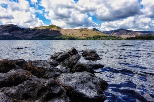
Derwent Water View, Cumbria by Michael Dambach,                                derwentwater cumbria bigsky clouds water summer catbells keswick
Derwent Water View, Cumbria by Michael Dambach
Ladybower Bridge by Andy Watson1, road park uk bridge blue trees summer england tree green water architecture canon reflections landsc
Ladybower Bridge by Andy Watson1
The Village of Hayfield, High Peak, Derbyshire, England. by westport 1946, In the centre of the village is the cricket ground where today Hayfield are playing Mottram in a loc
The Village of Hayfield, High Peak, Derbyshire, England. by westport 1946
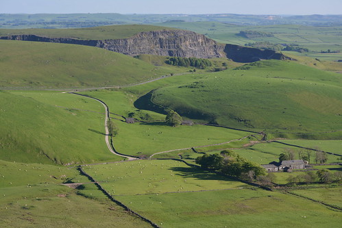
Eldon Hill Disused Quarry, Peak District National Park, Derbyshire, England. by westport 1946, Quarrying started at Eldon Hill in 1950 and finished in 1999.england unitedkingdom peakdistrict high
Eldon Hill Disused Quarry, Peak District National Park, Derbyshire, England. by westport 1946
Broadlee-Bank Tor, Peak District National Park, Derbyshire, England. by westport 1946, england unitedkingdom nationalpark thenationaltrust highpeak peakdistrict edale valeofedale bluesky
Broadlee-Bank Tor, Peak District National Park, Derbyshire, England. by westport 1946
30408 by benbobjr, Black Tor on the Great Ridge that separates Castleton and Edale in the Peak District, Derbyshire.
30408 by benbobjr
Back Tor View by johngregory250666, Another View from Back Tor , on Derwent Edge Deceember 2019, Peak District, Derbyshire, UKthe river
Back Tor View by johngregory250666
rushup edge by Phil-Gregory, rushup edge taken from mam tor peak district Derbyshire at sun down mamtor nikon d7200 tokina 1120mm
rushup edge by Phil-Gregory
Derwent Edge, End of Summer by Peter Quinn1, The view North-West from Derwent Edge towards an expanse of heather-clad moorland. The distinctive t
Derwent Edge, End of Summer by Peter Quinn1
45407 Rounds  Combs Reservoir.  30/11/2008 by briandean2, Black 5 45407 steams around the southern edge of Combs Reservoir and climbs towards Buxton hauling '
45407 Rounds Combs Reservoir. 30/11/2008 by briandean2
Down the ridge by Phil-Gregory, the great ridge ,park district national park uk at sunset nice nikon d7200 tokina tokina1120mmatx 11
Down the ridge by Phil-Gregory
Mam Tor by Peter Quinn1, A pleasant spring evening on a quiet Mam Tor summit.mamtor peakdistrict evening springevening summit
Mam Tor by Peter Quinn1
Wild HFF by Phil-Gregory, up on kinder scout in the peak district ,on a bleak daynikon d7200 naturalphotograph naturephotograp
Wild HFF by Phil-Gregory
The Path To Edale, Peak District National Park, Derbyshire, England. by westport 1946, england unitedkingdom highpeak peakdistrict nationalpark thenationaltrust derbyshire valeofedale val
The Path To Edale, Peak District National Park, Derbyshire, England. by westport 1946
Old fence by Phil-Gregory, Fence on the Great Ridge Peak District Edalefence nikon d7200 tokina1120mmatx tokina wideangle ultra
Old fence by Phil-Gregory
29927 by benbobjr, Walking down from Black Tor towards Hollins Cross, the end part of the Great Ridge that separates Ca
29927 by benbobjr
Moody sky by l4ts, A view of Crook Hill, the Woodlands Valley and a cloud-capped Win Hill seen from Crookstone Out Moor
Moody sky by l4ts
Brown Knoll by l4ts, Looking north-east from the trig column on Brown Knoll. I bet it doesn't look like this today!landsc
Brown Knoll by l4ts
Hope Valley. by Ade McCabe, Wild camp on Stanage Edge last night. 

I had the whole edge to myself from about 20:00 on. Set up a
Hope Valley. by Ade McCabe
Ashopton Viaduct by l4ts, Ashopton Viaduct which carries the A57 Snake Pass Road across Ladybower Reservoir.landscape derbyshi
Ashopton Viaduct by l4ts
Social distancing on Mam Tor by PentlandPirate: Slapdash Photography, We were all expecting a great inversion.  God had turned the cooker on that causes the mist to boil
Social distancing on Mam Tor by PentlandPirate: Slapdash Photography
Tunstead Works by l4ts, A view of the dystopian but also interesting scene that is Tunstead Limestone Works.landscape derbys
Tunstead Works by l4ts
Trio by l4ts, A group of three wind-blown trees overlooking Bradwell Dale.landscape derbyshire peakdistrict darkpe
Trio by l4ts
Rushing in to Rushup by PentlandPirate: Slapdash Photography, I had rushed to Mam Tor very early on Monday morning before I took a long way round to work, to see
Rushing in to Rushup by PentlandPirate: Slapdash Photography
27720 by benbobjr, Looking out from Black Tor on the Great Ridge that separates Castleton and Edale in the Peak Distric
27720 by benbobjr
Edale by l4ts, The view east along the Vale of Edale. landscape derbyshire peakdistrict darkpeak edale panorama the
Edale by l4ts
The Vale of Edale by l4ts, A view along the Vale of Edale from the top of Jacob's Ladder.
A monochrome version of an earlier up
The Vale of Edale by l4ts
Trees by l4ts, A view of the two lonely trees of Crookstone Out Moor on the eastern end of Kinder scout.landscape d
Trees by l4ts
Mam Tor Derbyshire by teamyam, After a 6.30am start (not early by serious types) and a little trek up to Mam Tor gate (a popular va
Mam Tor Derbyshire by teamyam
Mount Famine and South Head by l4ts, The view from the summit rocks of Mount Famine looking towards South Head.landscape derbyshire peakd
Mount Famine and South Head by l4ts
Fair Brook by l4ts, A waterfall along Fair Brook in the Woodlands Valley on the northern side of Kinder Scout. landscape
Fair Brook by l4ts
High Peak Panorama by l4ts, Mount Famine and South Head forming the middle ground in this view with Kinder Scout and Brown Knoll
High Peak Panorama by l4ts
Nether Moor by l4ts, The view out across the patchwork of Nether Moor at the eastern end of Kinder Scout towards the entr
Nether Moor by l4ts
Cave Dale by l4ts, Peveril Castle and Cave Dale near Castleton.landscape derbyshire peakdistrict whitepeak hopevalley c
Cave Dale by l4ts
Edale by l4ts, The Vale of Edale seen from Back Tor on the Great Ridge.landscape derbyshire peakdistrict darkpeak e
Edale by l4ts
Crookstone Out Moor by l4ts, A view along the Woodlands Valley towards Crook Hill from Crookstone Out Moor on the eastern end of
Crookstone Out Moor by l4ts
27285 by benbobjr, Approaching Hollins Cross, with behind that Lose Hill on the Great Ridge that separates Castleton an
27285 by benbobjr
The Limestone way...Cave dale. by A tramp in the hills, We rose out of the mists in Cave dale and looking back we were treated to a view of Peveril castle.c
The Limestone way...Cave dale. by A tramp in the hills
Sunrise by l4ts, Snowdrifts on the climb up Win Hill.landscape derbyshire peakdistrict darkpeak goldenhour sunrise ho
Sunrise by l4ts
Crookstone Hill by l4ts, The view from Kinder scout over Crookstone Hill towards Win Hill and Crook Hill.landscape derbyshire
Crookstone Hill by l4ts
Seal Edge by l4ts, A view east along Seal Edge on the northern side of Kinder Scout.landscape derbyshire peakdistrict d
Seal Edge by l4ts
Rushup Edge by l4ts, Low cloud rolling over Rushup Edge.landscape derbyshire peakdistrict darkpeak edale rushupedge mamto
Rushup Edge by l4ts
Back Tor by l4ts, Back Tor on the Great Ridge separating Edale and the Hope Valley.landscape derbyshire peakdistrict d
Back Tor by l4ts
Werneth Low by Toby Howard, Werneth Low Country Park is a lovely spot on the borders of Stockport and Tameside, with beautiful v
Werneth Low by Toby Howard
Rays by l4ts, Crepuscular rays shining down through the misty woodland by Ladybower Reservoir.landscape derbyshire
Rays by l4ts
Grindsbrook by l4ts, The head of Grindsbrook on Kinder Scout with a fellow walker admiring the view on this chilly mornin
Grindsbrook by l4ts
Mount Famine by l4ts, A just-before sunrise view of Mount Famine from the path to South Head. Every bit as cold as it look
Mount Famine by l4ts
Crook Hill Panorama by l4ts, A panorama from the summit of Crook Hill above Ladybower Reservoir shortly after sunrise. This takes
Crook Hill Panorama by l4ts
The Cloughs by smir_001, Pennine Way, Jacob’s Ladder & the Cloughs walk series. Taken from Pennine Way. It was the last w
The Cloughs by smir_001
Tunstead Works by l4ts, A view of the Tunstead Works quarry site near Buxton.landscape derbyshire peakdistrict buxton quarry
Tunstead Works by l4ts
Grainfoot Clough by l4ts, Grainfoot Clough below Derwent Edge. landscape derbyshire peakdistrict darkpeak upperderwentvalley d
Grainfoot Clough by l4ts
Grindslow Knoll by l4ts, The view south-west from Grindslow Knoll to the sunlit  hills of Colborne and Horsehill Tor at the w
Grindslow Knoll by l4ts
Ashopton Viaduct by l4ts, A long exposure image of Ashopton Viaduct and Ladybower Reservoir taken using a 10 stop filter.lands
Ashopton Viaduct by l4ts
Alport Castles by l4ts, The Tower, part of the Alport Castles landslip in Alport Dale.landscape derbyshire peakdistrict dark
Alport Castles by l4ts
The Limestone way...Cave dale. by A tramp in the hills, Headed to Castleton today to walk the first section of the Limestone way. limestoneway castleton cav
The Limestone way...Cave dale. by A tramp in the hills
Derwent Reservoir by l4ts, A view of the very dry northern end of Derwent Reservoir. On the right of the image can be seen the
Derwent Reservoir by l4ts
Bleaklow Stones by l4ts, An overall view of Bleaklow Stones under a striking cloudscape.landscape derbyshire peakdistrict dar
Bleaklow Stones by l4ts