Elevation of Waterfall Dr, Johnstown, PA, USA

Location: United States > Pennsylvania > Cambria County > Middle Taylor Township >

Longitude: -78.891690

Latitude: 40.3856218

Elevation: 478m / 1568feet

Barometric Pressure: 96KPa

Elevation Map:

elevation map of Waterfall Dr, Johnstown, PA, USA

Satellite Map:

Satellite map of Waterfall Dr, Johnstown, PA, USA

Related Photos:

johnstownpa inclinedplane pennsylvania pa johnstownpennsylvania inclined warehouse industrial inclinetracks cityofjohnstown
Stone Arch Bridge, Warehouse and Industrial area in Johnstown Pennsylvania
nps pennsylvania nationalmemorial johnstownflood
Johnstown Flood National Memorial
1889 johnstown flood disaster cityinruins postcard pennsylvania vintage
Johnstown Flood, 1889 - View of the City After the Flood - Johnstown, Pennsylvania
pennsylvania johnstown incline
Johnstown Inclined Plane
unitedstates pennsylvania johnstown
Two views at once
house snow unger johnstownflood
The Unger House
horse vintage advertising carriage postcard 1909 dualview
Hubbard's Wire Sewed Folding Delivery Boxes - Minneapolis, Minnesota
theinclinedplanejohnstownpa roncogswell inclinedplanecarandsideviewjohnstownpa sideviewofaninclinedplanecarjohnstownpa johnstownpa
Inclined Plane Car And Side View Johnstown (PA) August 2017
ns norfolksouthern pittsburghline pennsy pennsylvania positionlight signal signalbridge sunset silhouette summerhill railroad
LAST CALL
Eastbound at Summerhill
Shoving Hard On An Eastbound at South Fork
pennsylvania pa johnstownpa inclined inclinedplane johnstownpennsylvania cityofjohnstown inclinetracks
View form the top, The Johnstown Inclined Plane
pennsylvania pa johnstownpa inclinedplane cambriacounty cambriaironcompany viewfromthetopoftheinclinedplane cambriasteelco
Johnstown Pennsylvania, Cambria Iron Company
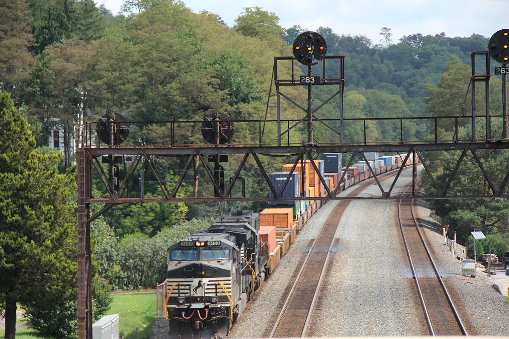
norfolksouthern ns9458
NS in Summerhill: 7
Conemaugh & Black Lick #116 Johnstown, Pennsylvania
A View of the Mountains...
snow dam southfork johnstownflood
View of The South Fork Dam
tower church architecture religious sandstone flood pennsylvania religion gothic methodist roofline johnstown merger unitedmethodist rosewindow brethren richardsonianromanesque nationalregister cambriacounty nrhp evangelicalunitedbrethren akronplan
Johnstown, PA-- First United Methodist Church, 1910
pennsylvania posterized johnstown inclinedplane neighborhoody
Johnstown, PA -view from top of the inclined plane
pennsylvania tracks pa johnstownpa inclined inclinedplane johnstownfloodmuseum cityofjohnstown inclinetracks
Johnstown PA Inclined Plane tracks and a city view
inclinedplanejohntownpa viewofjohnstownpafromtheinclinedplane roncogswell funicular
View of Johnstown (PA) from the Inclined Plane August 2017
train trains emd sw7 locomotive switching shortline short line urbna steel mill rails sunrise snow cold shop conemaugh black lick cbl 104 johnstown pa pennsylvania
The Yellow Switcher
2019 america americana appalachia cambriacounty coalcountry dreary factoryvalleys fronterastudio johnstown lookingatappalachia milltown pennsylvania postindustrial rain rural rustbelt snow sociallandscape travel westernpa unitedstatesofamerica
.
2019 america americana appalachia cambriacounty coalcountry dreary factoryvalleys fronterastudio johnstown lookingatappalachia milltown pennsylvania postindustrial rain rural rustbelt snow sociallandscape travel unitedstatesofamerica
.
clouds unitedstates pennsylvania sunny bluesky johnstown
Green, and Blue
monongahela heritage unit mga 8025 summerhill west slope 776 ns norfolk southern railroad trains locomotives pittsburgh line cambria county transportation outside scenic scenery landscape georgeneat patriotportraits neatroadtrips prr signal bridge
NS 776 with MGA
pennsylvania johnstown flood 1889 cityinruins postcard vintage
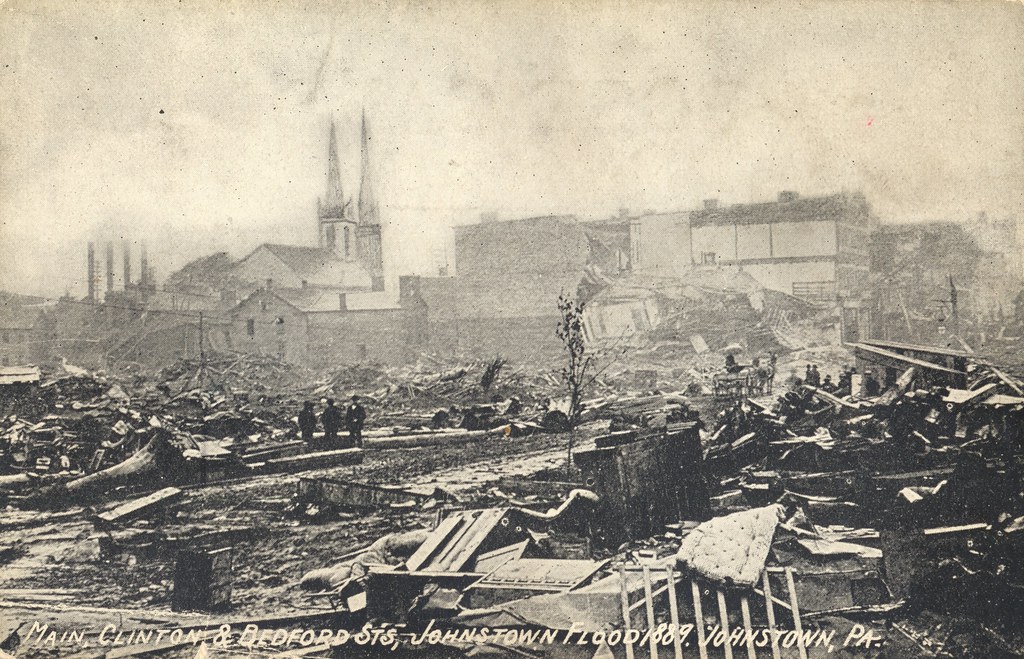
Johnstown Flood, 1889 - Main, Clinton & Bedford Streets - Johnstown, Pennsylvania
15909 usa ns eastconemaugh pa places johnstown pennsylvania unitedstates us
Horse Shoe Curve Trip-033
johnstown pennsylvania fountain
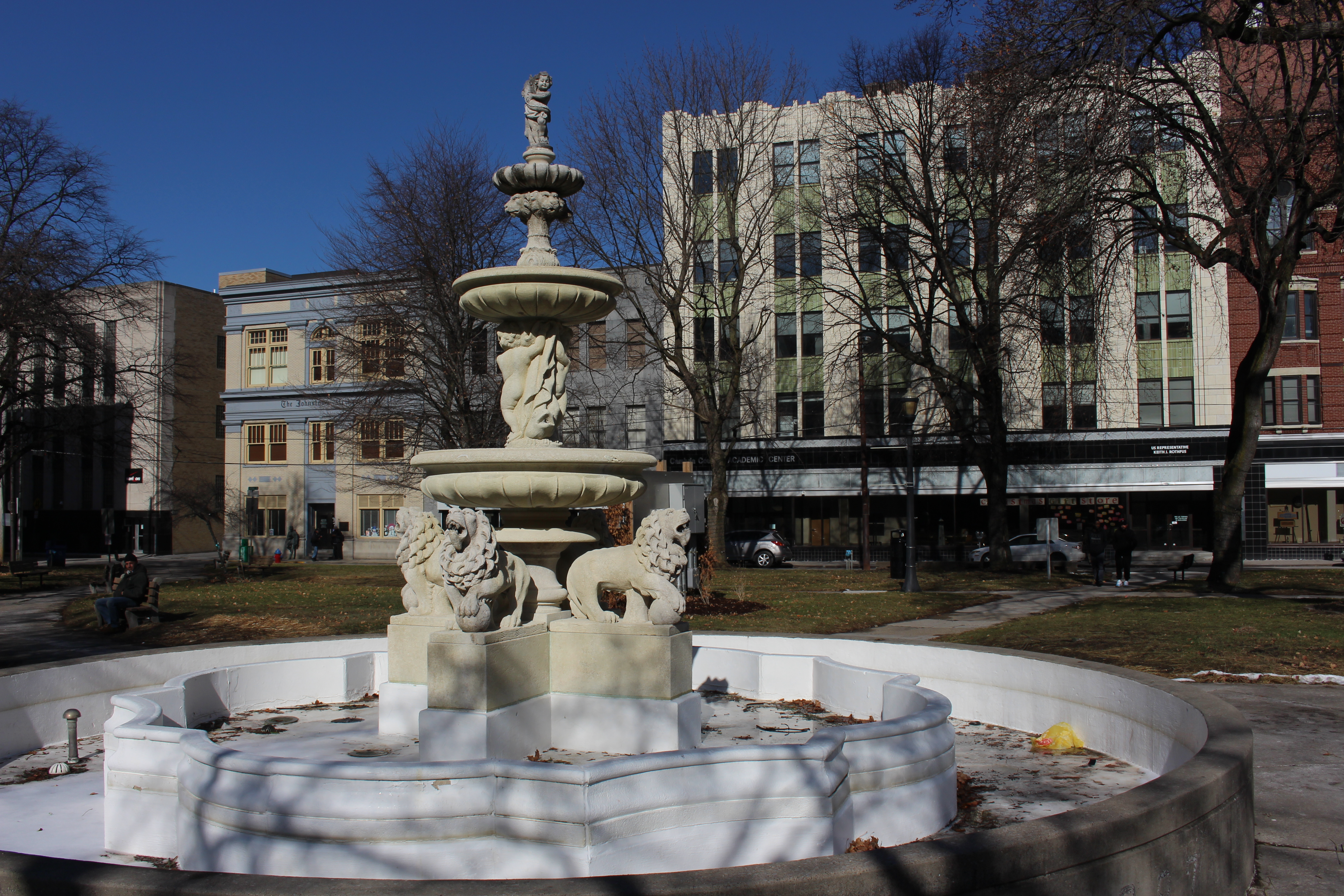
Central Park, Johnstown, PA
pennsylvania johnstown ironworks steelmill nationalhistoriclandmark conemaughriver cambriaironworks
Cambria Iron Works
railroad usa pennsylvania southfork johnstownflood johnstownfloodnationalmemorial lakeconemaugh littleconemaughriver southforkcreek
Close View of the failed South Fork Dam
eliza furnace industry iron ore stone stonework labor ritters historical landmark indiana county pa pennsylvania buildings structures georgeneat patriotportraits neatroadtrips scenic landscapes
Eliza Furnace
panorama clouds buildings town unitedstates pennsylvania mining powerplant hugin windber industrialbuildings mine40 smcpa28mmf28 panoramaoutput
Mine 40 near Windber, PA
Greater Johnstown High School
eliza furnace industry iron ore stone stonework labor ritters historical landmark indiana county pa pennsylvania buildings structures georgeneat patriotportraits neatroadtrips scenic landscapes
Eliza Furnace
pennsylvania canona1 johnstown portra800 inclineplane mikegrados
Johnstown, PA
travel snow history fog clouds day flood pennsylvania southfork johnstownflood johnstownfloodnationalmemorial lakeconemaugh pwwinter
The old site of Lake Conemaugh
blacklick creek ghosttowntrail scenic scenery landscapes indiana county pa pennsylvania georgeneat patriotportraits neatroadtrips fall
Ghost Town Trail
nspittsburghline ns25z ns4134 geac44c6m
NS 25Z at South Fork, Pennsylvania on August 29, 2018
landscape design unitedstates pennsylvania decay explorer pa attractive greenplanet newflorence canoncamera canon60d garysprague explorepa conemaughpowerplant
Conemaugh Generating Station
trees plants field fog unitedstates pennsylvania air hill agriculture summerhill tamronaf70300mmf456lddimacro
Across the field
pennsylvania johnstown inclinedplane
Johnstown, PA