Elevation of County Rd W, Columbia City, IN, USA

Location: United States > Indiana > Whitley County > Union Township > Columbia City >

Longitude: -85.565933

Latitude: 41.1157198

Elevation: 265m / 869feet

Barometric Pressure: 98KPa

Elevation Map:

elevation map of County Rd W, Columbia City, IN, USA

Satellite Map:

Satellite map of County Rd W, Columbia City, IN, USA

Related Photos:

columbiacity indiana sherrifshouse jail secondempire victorian whitleycounty whitleycountyjail
Columbia City Jail Detail
2015 20151107 bluerivertrail columbiacity columbiacityindiana columbiacitylandscape fortwaynemetropolitanarea img2617 indiana indianalandscape november november2015 whitleycounty whitleycountyindiana criscrossmowing distantbuildings expanse grass landscape lawn lawnlandscape mowed mowedarea mowedexpanse mowedgrass mowedgrid mowedlandscape mowedlawn northindiana northeastindiana northeasternindiana northernindiana partlycloudy radiotowers radiotransmissiontowers turfgrass view
Mown grid. This is in Indiana.
railroad train pentax ns engine indiana railway locomotive norfolksouthern emd railfanning diesellocomotive coaltrain whitleycounty sd70ace electromotivedivision k20d heritageunits smcpda1645mmf40edal southwhitleyindiana emdsd70ace nschicagodistrict ns866 ns8098 nsheritageunits ns1072
NS 1072, NS Chicago District, South Whitley, Indiana
2015 20151107 blueriver blueriverlandscape columbiacity columbiacityindiana columbiacitylandscape eelriverdrainagebasin eelriverwatershed fortwaynemetropolitanarea highway9 img2521 indiana indiana9 indianahighway9 indianaroute9 indianastateroad9 indianastateroute9 indianalandscape mainstreet november november2015 ohioriverdrainagebasin ohioriverwatershed route9 southmainstreet wabashriverdrainagebasin wabashriverwatershed whitleycounty whitleycountyindiana autumnlandscape creek creeklandscape electriclines electricpole falllandscape junipers landscape northindiana northeastindiana northeasternindiana northernindiana overheadelectriclines overheadpowerlines partlycloudy powerlines river riverlandscape riverinelandscape stream streamlandscape telephonepole utilitypole view viewfromabridge txtchg
The Blue River is my favorite river in the entire Eel River drainage basin. You know what I'm talking about.
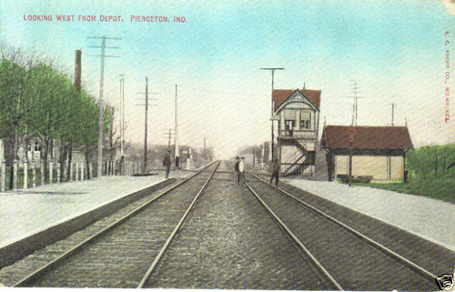
railroad piercetonindiana
View looking west from Pierceton Depot
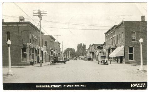
indiana pierceton
Pierceton Postcard, c. 1925
indiana pierceton
View from Pierceton Water Tower
indiana pierceton
Pierceton Railroad tracks, c. 1915
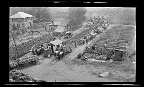
indiana canning pierceton reidmurdoch tomatofarming
PPL-003-804e_300
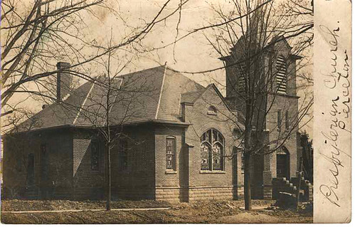
church presbyterian piercetonindianahistoricphotopostcard
Pierceton Presbyterian Church 1907
county old blue red grass barn rural golden fluffy indiana hills grassland fortwayne in cloulds whitley
Red Barn, Whitley County, IN
iphonepics
Iphone pics 980
unitedstates indiana columbiacity
Indiana Countryside
iphonepics
Iphone pics 979
field wheat country indiana
Straw Field
neglect canon rust decay nail corrosion corroded s90
Knock me Down B/W
iphonepics
Iphone pics 176
Playing at Grandpa Gorski's House - April 13 2010 - 065
Playing at Grandpa Gorski's House - April 13 2010 - 509
Playing at Grandpa Gorski's House - April 13 2010 - 065
Playing at Grandpa Gorski's House - April 13 2010 - 509
Playing at Grandpa Gorski's House part 2 - April 13 2010 - 10
Playing at Grandpa Gorski's House - April 13 2010 - 509
Playing at Grandpa Gorski's House - April 13 2010 - 345