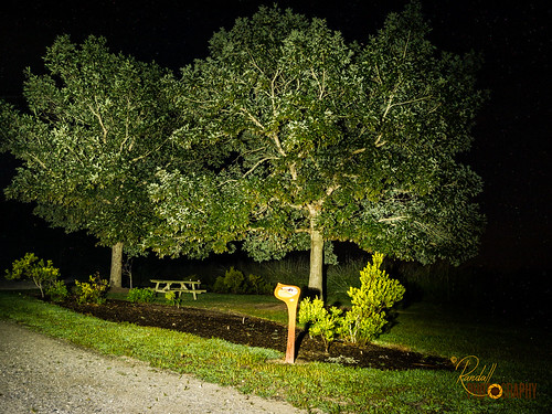
Latitude: 39.0383837
Longitude: -76.0623979
Elevation: 17 meters / 56 feet
Barometric Pressure 1011KPa

Related Photos

Light Trail Under the Moon by Randy • R, This is at night at Ocean Gateway close to Queenstown, MD. Practising "Long Exposure". Tak
Light Trail Under the Moon by Randy • R
I'm Dreaming by Randy • R, This is in the park Adkins Arboretum. I like this picture a lot because is one of my first pictures
I'm Dreaming by Randy • R
The Green Wheat Field by Randy • R, This is a wheat field close to my house located in Queen Anne's, MD US. This field is immense but al
The Green Wheat Field by Randy • R
Night Lightning Storm by Randy • R, This is at night at Adkins Arboretum located in Ridgely, MD. I learn about “Long Exposure” and I wan
Night Lightning Storm by Randy • R
View from the back deck on an autumn morning by vmi63,
View from the back deck on an autumn morning by vmi63
The Bright Moon by Randy • R, This is at night at Adkins Arboretum located in Ridgely, MD. I learn about "Long Exposure"
The Bright Moon by Randy • R
Light Painting in the Park - Trees by Randy • R, This is at night at Adkins Arboretum located in Ridgely, MD. I use my flashlight for light painting
Light Painting in the Park - Trees by Randy • R
The Green Wheat by Randy • R, This is a field of wheat close to my house located in Queen Anne's, MD US. This field is immense but
The Green Wheat by Randy • R
Green Wheat Stand Up by Randy • R, This is a field of wheat close to my house located in Queen Anne's, MD US. This field is immense but
Green Wheat Stand Up by Randy • R
RED FOX by nflravens, The preferred habitat of red foxes is a mixed landscape—comprising patches of forests, grasslands, a
RED FOX by nflravens
Corsica River living shoreline in Queen Anne's County, Maryland by chesbayprogram, A living shoreline built to withstand sea level rise due to climate change is seen on July 20, 2017,
Corsica River living shoreline in Queen Anne's County, Maryland by chesbayprogram
Eastern Neck National Wildlife Refuge by U. S. Fish and Wildlife Service - Northeast Region, Credit: USFWSneck landscape md wildlife maryland national eastern usfws refuge nationalwildliferefug
Eastern Neck National Wildlife Refuge by U. S. Fish and Wildlife Service - Northeast Region
Eastern Neck National Wildlife Refuge controlled burn by U. S. Fish and Wildlife Service - Northeast Region, March, 2011, Eastern Neck National Wildlife Refuge, Maryland:  A controlled burn helps keep invasive
Eastern Neck National Wildlife Refuge controlled burn by U. S. Fish and Wildlife Service - Northeast Region
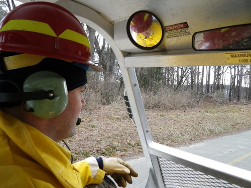
View from inside Marshmaster by U. S. Fish and Wildlife Service - Northeast Region, March, 2011, Eastern Neck National Wildlife Refuge, Maryland.  A firefighter drives a tracked, amphi
View from inside Marshmaster by U. S. Fish and Wildlife Service - Northeast Region
St. Joseph's near Cordova, Maryland, 1765 by Big Mike 42, Headquarters of Jesuit missionary activity in the mid-Delmarva Pensula from 1765 until 1874.  Cathol
St. Joseph's near Cordova, Maryland, 1765 by Big Mike 42
Restored wetlands in Queen Anne's County, Maryland by chesbayprogram, Bloomfield Farm, seen on July 20, 2017, is a permanently protected 318-acre property with roughly 10
Restored wetlands in Queen Anne's County, Maryland by chesbayprogram
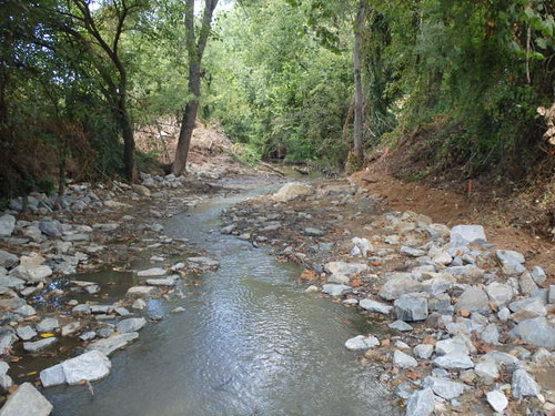
Centreville Dam rock ramp, downstream view by U. S. Fish and Wildlife Service - Northeast Region, This Hurricane Sandy resilience project removes the Centreville Dam in Centreville, Maryland, provid
Centreville Dam rock ramp, downstream view by U. S. Fish and Wildlife Service - Northeast Region
Restored wetlands in Queen Anne's County, Maryland by chesbayprogram, Bloomfield Farm, seen on July 20, 2017, is a permanently protected 318-acre property with roughly 10
Restored wetlands in Queen Anne's County, Maryland by chesbayprogram
Bird banding by U. S. Fish and Wildlife Service - Northeast Region, Refuge employees banding a duck at Eastern Neck National Wildlife Refuge. Credit: USFWSbird neck lan
Bird banding by U. S. Fish and Wildlife Service - Northeast Region
Riparian forest buffer in Queen Anne's County, Md. by chesbayprogram, A recently planted riparian forest buffer borders an agricultural field along Emory Creek, which flo
Riparian forest buffer in Queen Anne's County, Md. by chesbayprogram
Eastern Neck National Wildlife Refuge in Kent County, Md. by chesbayprogram, Phragmites and other shoreline wetland plants grow near a restoration project that uses a living sho
Eastern Neck National Wildlife Refuge in Kent County, Md. by chesbayprogram
Corsica River living shoreline in Queen Anne's County, Maryland by chesbayprogram, A living shoreline built to withstand sea level rise due to climate change is seen on July 20, 2017,
Corsica River living shoreline in Queen Anne's County, Maryland by chesbayprogram
Wye Mills Lake Spill by starg82343, Format: Anaglyph Color Version.
Red/Cyan 3D glasses required for viewing.

OOF (Out Of Frame), also
Wye Mills Lake Spill by starg82343
Restored wetlands in Queen Anne's County, Maryland by chesbayprogram, Bloomfield Farm, seen on July 20, 2017, is a permanently protected 318-acre property with roughly 10
Restored wetlands in Queen Anne's County, Maryland by chesbayprogram
Corsica River living shoreline in Queen Anne's County, Maryland by chesbayprogram, A living shoreline built to withstand sea level rise due to climate change is seen on July 20, 2017,
Corsica River living shoreline in Queen Anne's County, Maryland by chesbayprogram
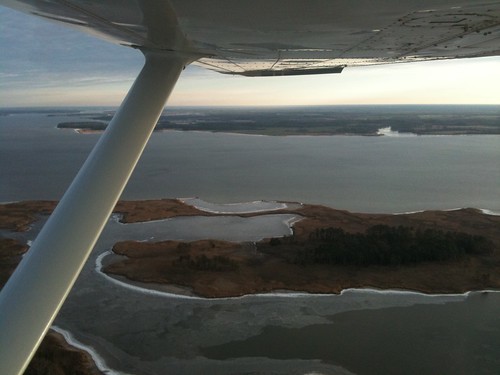
Aerial view of Hale Cove by U. S. Fish and Wildlife Service - Northeast Region, Eastern Neck National Wildlife Refuge. Credit: USFWSneck landscape md wildlife maryland aerial natio
Aerial view of Hale Cove by U. S. Fish and Wildlife Service - Northeast Region
Restored wetlands in Queen Anne's County, Maryland by chesbayprogram, Bloomfield Farm, seen on July 20, 2017, is a permanently protected 318-acre property with roughly 10
Restored wetlands in Queen Anne's County, Maryland by chesbayprogram
Corsica River living shoreline in Queen Anne's County, Maryland by chesbayprogram, A living shoreline built to withstand sea level rise due to climate change is seen on July 20, 2017,
Corsica River living shoreline in Queen Anne's County, Maryland by chesbayprogram
Restored wetlands in Queen Anne's County, Maryland by chesbayprogram, Bloomfield Farm, seen on July 20, 2017, is a permanently protected 318-acre property with roughly 10
Restored wetlands in Queen Anne's County, Maryland by chesbayprogram
Restored wetlands in Queen Anne's County, Maryland by chesbayprogram, Bloomfield Farm, seen on July 20, 2017, is a permanently protected 318-acre property with roughly 10
Restored wetlands in Queen Anne's County, Maryland by chesbayprogram
Corsica River living shoreline in Queen Anne's County, Maryland by chesbayprogram, A living shoreline built to withstand sea level rise due to climate change is seen on July 20, 2017,
Corsica River living shoreline in Queen Anne's County, Maryland by chesbayprogram
Route 301 in Queen Anne's County, Md. by chesbayprogram, Maryland Route 301, known as Blue Star Memorial Highway, runs toward Queenstown, Md., on June 27, 20
Route 301 in Queen Anne's County, Md. by chesbayprogram
0663_Tidal Marsh by robposse, Tidal marsh behind Visitor Center at Eastern Neck National Wildlife Refuge near Rock Hall, Maryland
0663_Tidal Marsh by robposse
Corsica River living shoreline in Queen Anne's County, Maryland by chesbayprogram, A living shoreline built to withstand sea level rise due to climate change is seen on July 20, 2017,
Corsica River living shoreline in Queen Anne's County, Maryland by chesbayprogram
Corsica River living shoreline in Queen Anne's County, Maryland by chesbayprogram, A living shoreline built to withstand sea level rise due to climate change is seen on July 20, 2017,
Corsica River living shoreline in Queen Anne's County, Maryland by chesbayprogram
Wye Mills Lake Spill by starg82343, Format: Crossview Grayscale Version.
Gently converge (cross) your eyes and focus on the middle image
Wye Mills Lake Spill by starg82343
Eastern Neck National Wildlife Refuge in Kent County, Md. by chesbayprogram, Phragmites reeds grow near a restoration project using a living shoreline, an artificial stone ribbo
Eastern Neck National Wildlife Refuge in Kent County, Md. by chesbayprogram
Wye Mills Lake Spill by starg82343, Format: Anaglyph Grayscale Version.
Red/Cyan 3D glasses required for viewing.

OOF (Out Of Frame), a
Wye Mills Lake Spill by starg82343
Corsica River living shoreline in Queen Anne's County, Maryland by chesbayprogram, A living shoreline built to withstand sea level rise due to climate change is seen on July 20, 2017,
Corsica River living shoreline in Queen Anne's County, Maryland by chesbayprogram
Corsica River in Queen Anne's County, Md. by chesbayprogram, The Corsica River is surrounded by farmland where it joins the Upper Chester River Sanctuary in Quee
Corsica River in Queen Anne's County, Md. by chesbayprogram
Restored wetlands in Queen Anne's County, Maryland by chesbayprogram, Bloomfield Farm, seen on July 20, 2017, is a permanently protected 318-acre property with roughly 10
Restored wetlands in Queen Anne's County, Maryland by chesbayprogram
Corsica River living shoreline in Queen Anne's County, Maryland by chesbayprogram, A living shoreline built to withstand sea level rise due to climate change is seen on July 20, 2017,
Corsica River living shoreline in Queen Anne's County, Maryland by chesbayprogram
Corsica River living shoreline in Queen Anne's County, Maryland by chesbayprogram, A living shoreline built to withstand sea level rise due to climate change is seen on July 20, 2017,
Corsica River living shoreline in Queen Anne's County, Maryland by chesbayprogram
Conquest Beach Living Shoreline in Queen Anne's County, Maryland by chesbayprogram, A living shoreline built to withstand sea level rise due to climate change is seen on July 20, 2017,
Conquest Beach Living Shoreline in Queen Anne's County, Maryland by chesbayprogram
Kent Island in Queen Anne's County, Maryland by chesbayprogram, Development covers low-lying marshland on either side of U.S. Route 50 in Kent Narrows, Md., on Marc
Kent Island in Queen Anne's County, Maryland by chesbayprogram
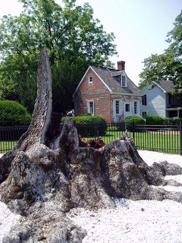
Wye Oak remains, 2004 by Big Mike 42, Wye Mills, Maryland.  For many decades the emblematic tree of Maryland, until it was destroyed by a
Wye Oak remains, 2004 by Big Mike 42
Agriculture in Queen Anne's County, Md. by chesbayprogram, Farmland near the Chester River is seen in Queen Anne's County, Md., on June 27, 2016. (Photo by Wil
Agriculture in Queen Anne's County, Md. by chesbayprogram
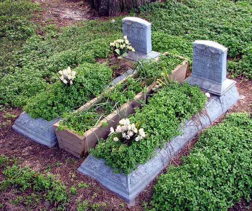
Budded on Earth to Bloom in Heaven by Big Mike 42, Grave markers of baby girls in the cemetery adjacent to St. Joseph's Catholic Church near Cordova, M
Budded on Earth to Bloom in Heaven by Big Mike 42
Corsica River living shoreline in Queen Anne's County, Maryland by chesbayprogram, A living shoreline built to withstand sea level rise due to climate change is seen on July 20, 2017,
Corsica River living shoreline in Queen Anne's County, Maryland by chesbayprogram
Eastern Neck National Wildlife Refuge in Kent County, Maryland by chesbayprogram, The Chester River wraps around Eastern Neck National Wildlife Refuge in Kent County, Md., on March 2
Eastern Neck National Wildlife Refuge in Kent County, Maryland by chesbayprogram
Corsica River living shoreline in Queen Anne's County, Maryland by chesbayprogram, A living shoreline built to withstand sea level rise due to climate change is seen on July 20, 2017,
Corsica River living shoreline in Queen Anne's County, Maryland by chesbayprogram
Kent Island in Queen Anne's County, Maryland by chesbayprogram, Development covers low-lying marshland on either side of U.S. Route 50 in Kent Narrows, Md., on Marc
Kent Island in Queen Anne's County, Maryland by chesbayprogram
STANDING TALL by nflravens, Today, Jan 16, 2009, the Eagle pair were perched in a tree alongside the road. In front of nesting a
STANDING TALL by nflravens
VIEWPOINT by nflravens, Today, Jan 9, 2009, the Eagle pair were perched in a tree alongside the road. In front of nesting ar
VIEWPOINT by nflravens
Queenstown Creek in Queen Anne's County, Md. by chesbayprogram, An osprey is seen in its nest on Queenstown Creek in Queen Anne's County, Md., on June 26, 2014. (Ph
Queenstown Creek in Queen Anne's County, Md. by chesbayprogram
Eastern Neck National Wildlife Refuge by chesbayprogram, Tundra swans dot the waters along the entrance to Eastern Neck National Wildlife in Kent County, Md.
Eastern Neck National Wildlife Refuge by chesbayprogram
Reed Creek in Queen Anne's County, Md. by chesbayprogram, Farmland, residential development and forest are seen near the headwaters of Reed Creek, a tributary
Reed Creek in Queen Anne's County, Md. by chesbayprogram
Kent Island in Queen Anne's County, Maryland by chesbayprogram, Development, including hardened shorelines and bulkheads, covers low-lying marshland on either side
Kent Island in Queen Anne's County, Maryland by chesbayprogram
Eastern Neck National Wildlife Refuge by chesbayprogram, Shoreline breakwater structures are seen at Eastern Neck National Wildlife Refuge in Kent County, Md
Eastern Neck National Wildlife Refuge by chesbayprogram
Kent Island in Queen Anne's County, Maryland by chesbayprogram, Development covers low-lying marshland on either side of U.S. Route 50 in Kent Narrows, Md., on Marc
Kent Island in Queen Anne's County, Maryland by chesbayprogram