Elevation of SP Foundry, W 4th St, South Coffeyville, OK, USA
Location: United States > Oklahoma > Nowata County > South Coffeyville >
Longitude: -95.628429
Latitude: 36.9957794
Elevation: -10000m / -32808feet
Barometric Pressure: 295KPa
Elevation Map:
Satellite Map:
Related Photos:

Condon Bank, Coffeyville

Utah and Travel

Utah and Travel

HDR Condon Bank side view
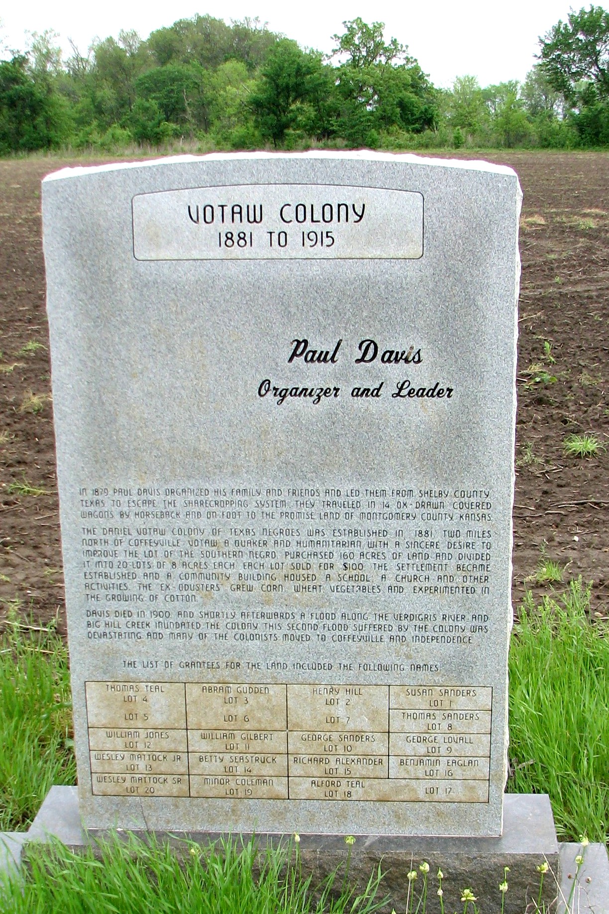
Votaw Colony

Utah and Travel
Utah and Travel
Memorial Hospital

Pumpkin Creek

Grand Canyon

Grand Canyon

Verdigris River

Restview Cemetery

Stateline Sunset

DSC_0040.JPG
Topographic Map of SP Foundry, W 4th St, South Coffeyville, OK, USA
Find elevation by address:

Places near SP Foundry, W 4th St, South Coffeyville, OK, USA:
Cherokee Casino South Coffeyville
Taylor Crane & Rigging
U-haul Neighborhood Dealer
Los Primos 2
Sonic Drive-in
Brown's Shoe Fit Co
Trinity United Methodist Church
V & S Family Center
Pizza Hut
Taco Bell
Field Kindley Memorial High School
3 Bedroom House
Green Acres Garden Center & Florist
Equity Bank
Buckeye Mobile Estates & Rv Park
Aspen Contracting, Inc.
Leclere Park Basketball Courts
Restlawn Memorial Park
Fairview Cemetery
Asbury Village
Recent Searches:
- Elevation of Bydgoszcz, Poland
- Elevation of Bydgoszcz, Poland
- Elevation of Calais Dr, Del Mar, CA, USA
- Elevation of Placer Mine Ln, West Jordan, UT, USA
- Elevation of E 63rd St, New York, NY, USA
- Elevation of Elk City, OK, USA
- Elevation of Erika Dr, Windsor, CA, USA
- Elevation of Village Ln, Finleyville, PA, USA
- Elevation of 24 Oakland Rd #, Scotland, ON N0E 1R0, Canada
- Elevation of Deep Gap Farm Rd E, Mill Spring, NC, USA