Elevation of Ralph Overman Ln, Liberty, NC, USA
Location: United States > North Carolina > Randolph County > Liberty > Liberty >
Longitude: -79.506163
Latitude: 35.896358
Elevation: 222m / 728feet
Barometric Pressure: 99KPa
Elevation Map:
Satellite Map:
Related Photos:

Belmont Cotton Mills, Graham, NC

Alamance Battleground State Historic Site (N.C.), 2 July 1972

150801-2040 Alamance
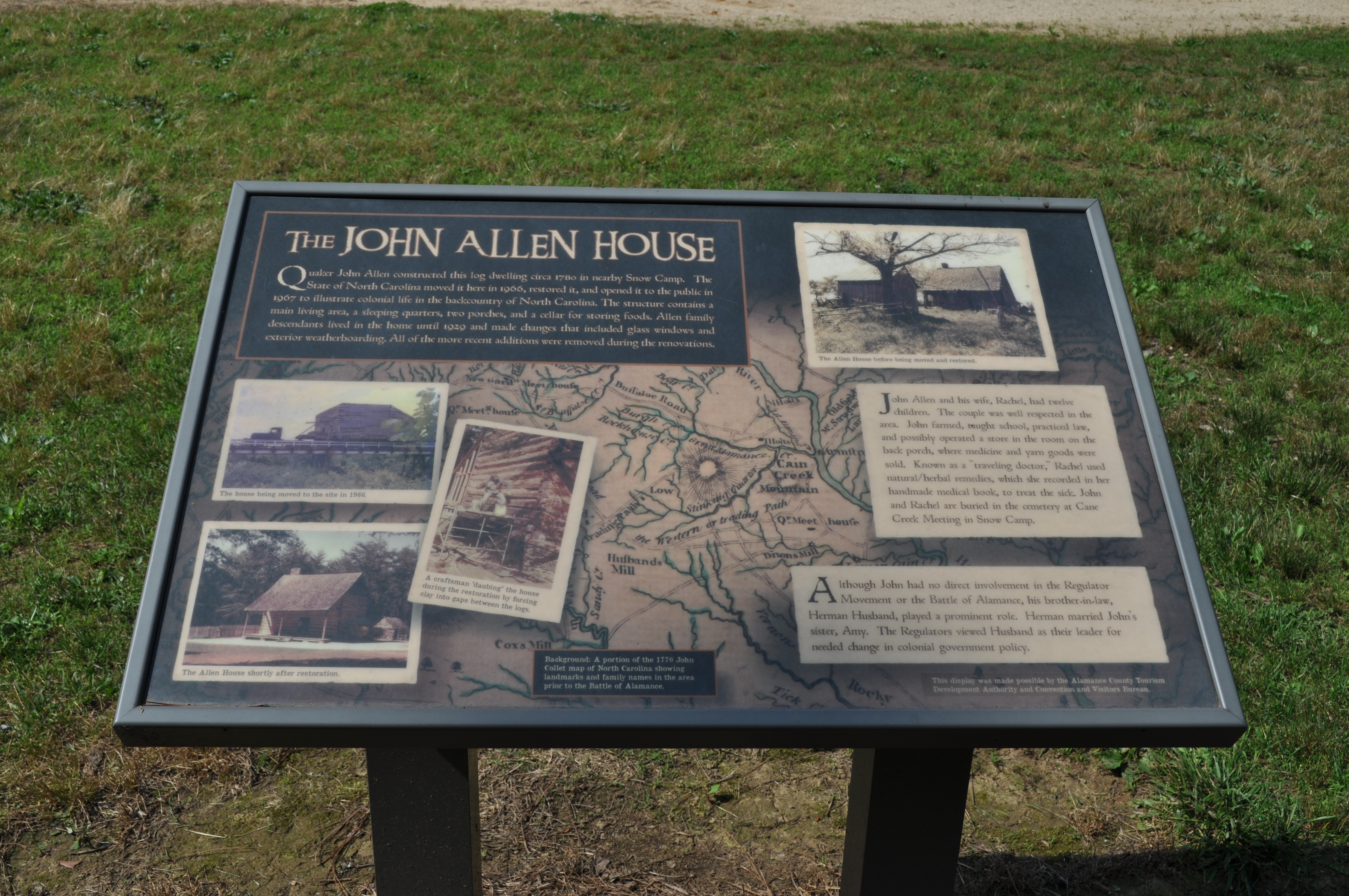
1162 The John Allen House Img_15756

1179 Battle Of Alamance Monument Img_15773

150801-2058 Alamance

The Trees in Line

Saturday Stillness #shotoniphone #landscape #pond #endoftheday

Country Side #shotoniphone #lightroommobile #countryside #rural_landscapes #backroads

Autumn Sun #northcarolina #iphonography #autumn #autumn2015 #sunset #sunshine #sunlight #sunsets #landscape #rural #autumntime

38. Liberty Water Tower

_MG_9676-2

Stormy Drive Home

Rapid and Moss

Kimesville Dam

250. Sunset on the way home...

Pine shadows

Cane Creek Farm

Cane Creek Farm

Cane Creek Farm Cookout

40. Whatchu lookin at?

The Mill Dam

Small Waterfall

Cedarock Park Hike

Fishing party

Driven Pheasant Hunt, Beaver Pond
Topographic Map of Ralph Overman Ln, Liberty, NC, USA
Find elevation by address:

Places near Ralph Overman Ln, Liberty, NC, USA:
1, Patterson
4259 W Greensboro Chapel Hill Rd
3006 Songbird Pl
Liberty
Liberty, NC, USA
Rock Creek
NC-49, Burlington, NC, USA
2, Coble
NC-62, Burlington, NC, USA
Climax
Forest Oaks
4600 Forest Oaks Dr
4309 Lormar Rd
4307 Lormar Rd
4303 Lormar Rd
4303 Lormar Rd
2318 Carlford Rd
5618 Dashwood Dr
Neelley Road
5409 Running Mead Rd
Recent Searches:
- Elevation of Corso Fratelli Cairoli, 35, Macerata MC, Italy
- Elevation of Tallevast Rd, Sarasota, FL, USA
- Elevation of 4th St E, Sonoma, CA, USA
- Elevation of Black Hollow Rd, Pennsdale, PA, USA
- Elevation of Oakland Ave, Williamsport, PA, USA
- Elevation of Pedrógão Grande, Portugal
- Elevation of Klee Dr, Martinsburg, WV, USA
- Elevation of Via Roma, Pieranica CR, Italy
- Elevation of Tavkvetili Mountain, Georgia
- Elevation of Hartfords Bluff Cir, Mt Pleasant, SC, USA