Latitude: -34.0762027
Longitude: 139.0507338
Elevation: 389 meters / 1276 feet
Barometric Pressure 967KPa

Related Photos

Ngapala near Point Pass. The memorial cairn to the Julia Creek mounted police station which operated on this creek from 1842 to 1846. by denisbin, Ngapala.
Ngapala lies between the Tothill Ranges to the west and the last escarpment of the Mount Lo
Ngapala near Point Pass. The memorial cairn to the Julia Creek mounted police station which operated on this creek from 1842 to 1846. by denisbin
Ngapala near Point Pass. Where Julia Creek rises. Old stone farm house in ruins. by denisbin, Ngapala.
Ngapala lies between the Tothill Ranges to the west and the last escarpment of the Mount Lo
Ngapala near Point Pass. Where Julia Creek rises. Old stone farm house in ruins. by denisbin
Ngapala near Point Pass. This government school opened in 1908 as Anlaby Public School. Soon changed to Ngapala School. Closed in 1938. Beyond it is the former Methodist Church. by denisbin, Ngapala.
Ngapala lies between the Tothill Ranges to the west and the last escarpment of the Mount Lo
Ngapala near Point Pass. This government school opened in 1908 as Anlaby Public School. Soon changed to Ngapala School. Closed in 1938. Beyond it is the former Methodist Church. by denisbin
Ngapala. Peacefull landscape at the site of the Julia Creek mounted police station which operated from 1842 to 1846 quite close to the Ngapala church and school. by denisbin, Ngapala.
Ngapala lies between the Tothill Ranges to the west and the last escarpment of the Mount Lo
Ngapala. Peacefull landscape at the site of the Julia Creek mounted police station which operated from 1842 to 1846 quite close to the Ngapala church and school. by denisbin
Ngapala near Point Pass. This government school opened in 1908 as Anlaby Public School. Soon changed to Ngapala School. Closed in 1938. Plaque in front of school with teachers listed. by denisbin, Ngapala.
Ngapala lies between the Tothill Ranges to the west and the last escarpment of the Mount Lo
Ngapala near Point Pass. This government school opened in 1908 as Anlaby Public School. Soon changed to Ngapala School. Closed in 1938. Plaque in front of school with teachers listed. by denisbin
Ngapala near Point Pass. This government school opened in 1908 as Anlaby Public School. Soon changed to Ngapala School. Closed in 1938. Plaque in front of school with all teachers listed. by denisbin, Ngapala.
Ngapala lies between the Tothill Ranges to the west and the last escarpment of the Mount Lo
Ngapala near Point Pass. This government school opened in 1908 as Anlaby Public School. Soon changed to Ngapala School. Closed in 1938. Plaque in front of school with all teachers listed. by denisbin
Ngapala near Point Pass. The memorial cairn to the Julia Creek mounted police station which operated on this creek from 1842 to 1846. Second part of the story. by denisbin, Ngapala.
Ngapala lies between the Tothill Ranges to the west and the last escarpment of the Mount Lo
Ngapala near Point Pass. The memorial cairn to the Julia Creek mounted police station which operated on this creek from 1842 to 1846. Second part of the story. by denisbin
Ngapala near Point Pass. The memorial cairn to the Julia Creek mounted police station which operated on this creek from 1842 to 1846. First part of the story. by denisbin, Ngapala.
Ngapala lies between the Tothill Ranges to the west and the last escarpment of the Mount Lo
Ngapala near Point Pass. The memorial cairn to the Julia Creek mounted police station which operated on this creek from 1842 to 1846. First part of the story. by denisbin
Heysen Trail, Tothill Range 30 by WEA Ramblers, hiking johncolley bushwalking tothillranges
Heysen Trail, Tothill Range 30 by WEA Ramblers
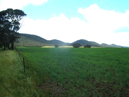
Heysen Trail, Tothill Range 01 by WEA Ramblers, hiking bushwalking tothillranges johncolley
Heysen Trail, Tothill Range 01 by WEA Ramblers
View of Eudunda from the Town Lookout. by PhotoChronologyOfSouthAustralia,
View of Eudunda from the Town Lookout. by PhotoChronologyOfSouthAustralia
Tree Line by LRP54, au australia buchanan southaustralia sonyslta99v lightroomcc
Tree Line by LRP54
Viewing platform by Runabout63, Eudunda South Australiaeudunda southaustralia
Viewing platform by Runabout63
Corner Balcony by mikecogh,                                eudunda southaustralia view mainstreet balcony rust roofs corner
Corner Balcony by mikecogh
2012 Copyworld Walk 100 - Robertstown Rally by philwillmedia, Image from the 2012 Robertstown Rally.
To see more images like this, visit <a href="http://www.freew
2012 Copyworld Walk 100 - Robertstown Rally by philwillmedia
Looking Over Eudunda by mikecogh,                                eudunda southaustralia view mainstreet hotel hills plains
Looking Over Eudunda by mikecogh
final view by leogaggl, green cemetery peaceful serene southaustralia midnorth
final view by leogaggl
Silo Dominance by mikecogh,                                eudunda southaustralia silos storage grain view roofs rust
Silo Dominance by mikecogh
Roberstown Rail Reserve by oz_lightning, australia canon6d canonef1635mmf4lis midnorth robertstown sa agriculture buildings crane history lan
Roberstown Rail Reserve by oz_lightning
Agricultural Contraption by oz_lightning, australia canon6d canonef1635mmf4lis midnorth robertstown sa agriculture buildings decay history lan
Agricultural Contraption by oz_lightning
Station Sign by oz_lightning, australia canon6d canonef1635mmf4lis heritage midnorth robertstown sa building landscape nature rail
Station Sign by oz_lightning
Agricultural Contraption on the Railway Reserve by oz_lightning, australia canon6d canonef1635mmf4lis midnorth robertstown sa agriculture buildings decay history lan
Agricultural Contraption on the Railway Reserve by oz_lightning
På väg till världens ände... by stiigviig, square squareformat iphoneography instagramapp uploaded:by=instagram
På väg till världens ände... by stiigviig