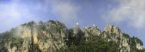
Elevation of Chae Hom District, Lampang, Thailand
Location: Thailand > Lampang >
Longitude: 99.6786894
Latitude: 18.7933822
Elevation: 427m / 1401feet
Barometric Pressure: 96KPa
Related Photos:
Topographic Map of Chae Hom District, Lampang, Thailand
Find elevation by address:

Places in Chae Hom District, Lampang, Thailand:
Places near Chae Hom District, Lampang, Thailand:
Chae Hom
Chaehom Thanaphong
Rong Kho
Wang Nuea District
Ban Mae Chaem Health Center
Ban Dong
Thep Sadet Witthaya School
On Nuea
Mae On
Mae Kachan Hot Spring And Geyser
Ban Sang
ทางหลวงชนบท ลป.4010
Mae Chedi Mai
Chiang Mai Highlands Golf And Spa Resort.
Ban Ueam
Mae On District
The Oriental Village
San Khamphaeng Hot Springs
Ban Sa Ha Khon
Mueang Lampang District, Lampang, Thailand
Recent Searches:
- Elevation of Corso Fratelli Cairoli, 35, Macerata MC, Italy
- Elevation of Tallevast Rd, Sarasota, FL, USA
- Elevation of 4th St E, Sonoma, CA, USA
- Elevation of Black Hollow Rd, Pennsdale, PA, USA
- Elevation of Oakland Ave, Williamsport, PA, USA
- Elevation of Pedrógão Grande, Portugal
- Elevation of Klee Dr, Martinsburg, WV, USA
- Elevation of Via Roma, Pieranica CR, Italy
- Elevation of Tavkvetili Mountain, Georgia
- Elevation of Hartfords Bluff Cir, Mt Pleasant, SC, USA


