Elevation of Bahadurwadi, Maharashtra, India
Location: India > Maharashtra > Sangli >
Longitude: 74.3147271
Latitude: 16.910557
Elevation: 569m / 1867feet
Barometric Pressure: 95KPa
Elevation Map:
Satellite Map:
Related Photos:

Sunset view captured while driving on highway.

Flood Relief : Pune
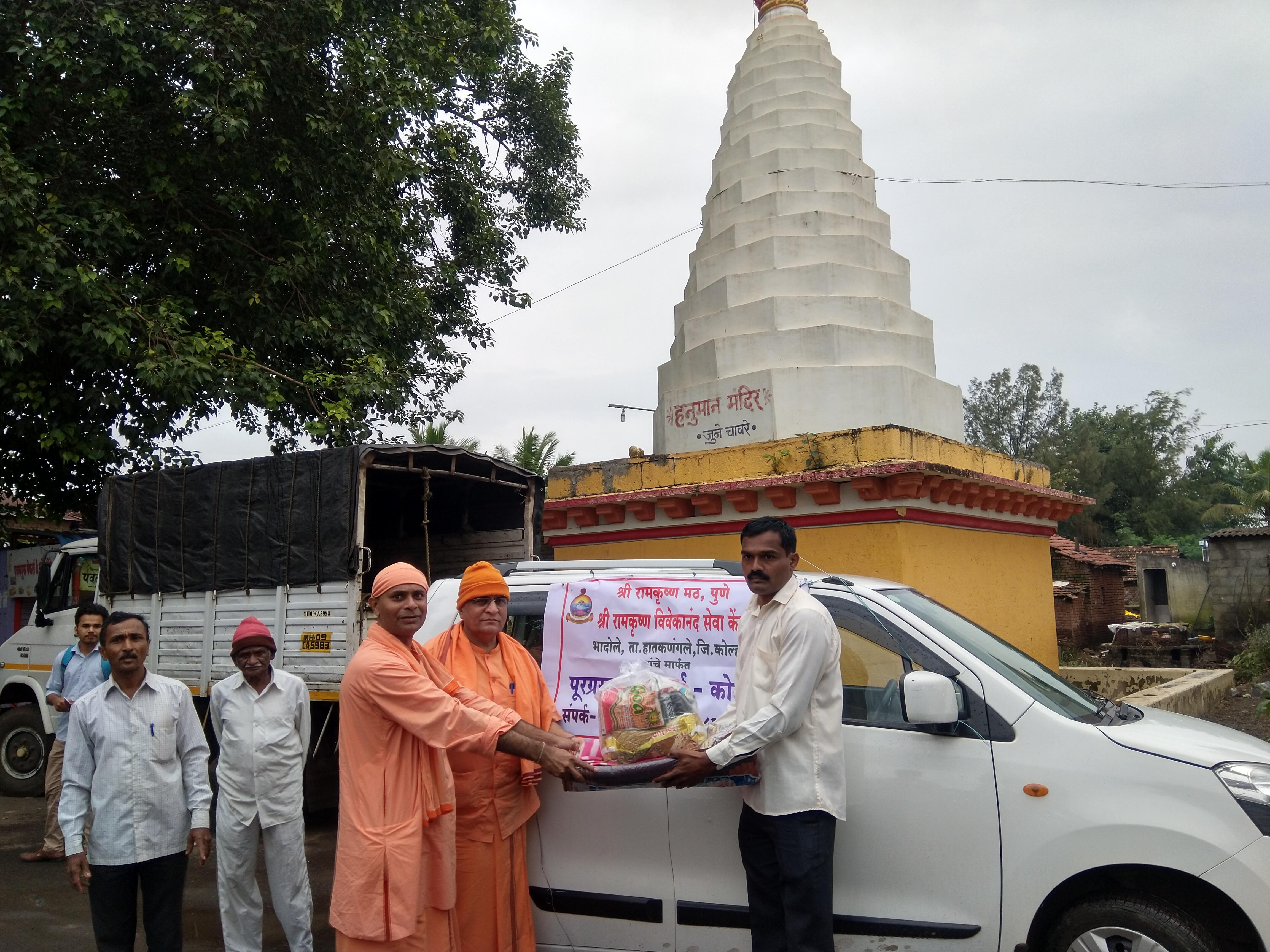
Flood Relief : Pune

KMT's beauty at Wadgaon near Aashta.

MH-20 / D 8002. Tasgaon depot's converted semi.

कणेरी मठ, पेठचा गणपती, जोतिबा, नरसोबाची वाडी, महालक्ष्मी कोल्हापूर.
Topographic Map of Bahadurwadi, Maharashtra, India
Find elevation by address:

Places near Bahadurwadi, Maharashtra, India:
Tandulwadi
Malewadi
Dhavali
Ghunki
Pokharni
Shigaon
Yelur
Chavare
Wathare Kirana Bagani
Yedenipani
Phalkewadi
Pandharmala
Rozawadi
Khot Mala
Lonarwadi
Nave Pargaon
Vashi
Gandhinagar
Tujarpur
Ashta
Recent Searches:
- Elevation of Corso Fratelli Cairoli, 35, Macerata MC, Italy
- Elevation of Tallevast Rd, Sarasota, FL, USA
- Elevation of 4th St E, Sonoma, CA, USA
- Elevation of Black Hollow Rd, Pennsdale, PA, USA
- Elevation of Oakland Ave, Williamsport, PA, USA
- Elevation of Pedrógão Grande, Portugal
- Elevation of Klee Dr, Martinsburg, WV, USA
- Elevation of Via Roma, Pieranica CR, Italy
- Elevation of Tavkvetili Mountain, Georgia
- Elevation of Hartfords Bluff Cir, Mt Pleasant, SC, USA