Elevation map of Pohnpei, Federated States of Micronesia

Location: Federated States Of Micronesia >

Longitude: 158.262382

Latitude: 6.8541254

Elevation: 311m / 1020feet

Barometric Pressure: 98KPa

Elevation Map:

elevation map of Pohnpei, Federated States of Micronesia

Satellite Map:

Satellite map of Pohnpei, Federated States of Micronesia

Related Photos:

japan earthquake nasa tsunami pacificocean quake sendal
GOES-11 Satellite Sees Pacific Ocean Basin After Japan Quake
ocean travel blue trees sea sky cloud seascape tree water coral clouds forest canon island rainforest aqua raw view bluesky palmtrees canopy coconuts nationalgeographic coralreef micronesia waterscape oceania pohnpei travelphotography rawphotography canonphotography federatedstatesofmicronesia canon7d aprilmoulton
A Room with a View
island pacific aircraft united jet boeing ual ua unitedairlines micronesia b737 737800 boeing737 ksr b737800 738 kosrae b738 federatedstatesofmicronesia islandhopper n25201 boeing738 federatedstates
United Airlines
airport airborne pohnpei pni ponape federatedstatesofmicronesia cruisair
PNI AIRPORT AIRVIEW
wine labels france julienas 1957 labelswine french text writing wineposter brexitwine voteremainin trump clinton borisjohnson neverendum clintonwin clintonvictory russianhackingtrumpvictory
Julienas 1957 French Wine Label
wine labels france saint croix du mont bordeaux labelswine writing wineposter brexitwine voteremainin trump clinton borisjohnson neverendum clintonwin clintonvictory russianhackingtrumpvictory
Saint Croix Du Mont Wine Label
tropicalisland fsm tropics micronesia pohnpei federatedstatesofmicronesia
Pohnpei Village view
bldigital date1878 pubplacelondon publicdomain sysnum003055004 reclusélisée large vol14 page349 mechanicalcurator imagesfrombook003055004 imagesfromvolume00305500414 map wp:bookspage=geography hasgeoref georefphase2 geo:osmscale=11 geo:continent=australasia geo:country=fm geo:country=federatedstatesofmicronesia geo:state=pohnpei sherlocknet:tag=mile sherlocknet:tag=water sherlocknet:tag=island sherlocknet:tag=land sherlocknet:tag=english sherlocknet:tag=town sherlocknet:tag=numeric sherlocknet:tag=populate sherlocknet:tag=france sherlocknet:tag=form sherlocknet:tag=place sherlocknet:tag=district sherlocknet:tag=slope sherlocknet:tag=import sherlocknet:tag=mass sherlocknet:category=maps
Image taken from page 349 of 'The Earth and its Inhabitants. The European section of the Universal Geography by E. Reclus. Edited by E. G. Ravenstein. Illustrated by ... engravings and maps'
ww2 fsm micronesia pohnpei antiaircraftgun federatedstatesofmicronesia ww2relic
Pohnpei Japanese antiaircraft guns
tropicalisland fsm tropics micronesia federatedstatesofmicronesia pohpnei thevillagehotel
Pohnpei Village hotel gazebo
tropicalisland fsm tropics micronesia traditionalarchitecture pohnpei federatedstatesofmicronesia
Pohnpei Village hotel
bldigital date1895 pubplacemanila publicdomain sysnum000562483 cabezapereiroanacleto large vol0 page109 mechanicalcurator imagesfrombook000562483 imagesfromvolume0005624830 map wp:bookspage=australiaandnewzealand georefphase2 sherlocknet:tag=form sherlocknet:tag=narrow sherlocknet:tag=england sherlocknet:tag=angle sherlocknet:tag=coast sherlocknet:tag=line sherlocknet:tag=sous sherlocknet:tag=course sherlocknet:tag=short sherlocknet:tag=northern sherlocknet:tag=local sherlocknet:tag=water sherlocknet:tag=point sherlocknet:tag=territory sherlocknet:tag=distance sherlocknet:category=maps hasgeoref geo:osmscale=12 geo:continent=australasia geo:country=fm geo:country=federatedstatesofmicronesia geo:state=pohnpei geo:city=sokehs
Image taken from page 109 of 'Estudios sobre Carolinas. La isla de Ponapé. Geografia, etnografia, historia ... Con un prólogo del ... Teniente General D. Valeriano Weyler. [With maps and plans.]'
bldigital date1895 pubplacemanila publicdomain sysnum000562483 cabezapereiroanacleto large vol0 page313 mechanicalcurator imagesfrombook000562483 imagesfromvolume0005624830 map wp:bookspage=australiaandnewzealand georefphase2 sherlocknet:tag=land sherlocknet:tag=house sherlocknet:tag=number sherlocknet:tag=blue sherlocknet:tag=western sherlocknet:tag=england sherlocknet:tag=care sherlocknet:tag=theiler sherlocknet:tag=state sherlocknet:tag=forth sherlocknet:tag=differ sherlocknet:tag=principe sherlocknet:tag=line sherlocknet:tag=ancient sherlocknet:tag=ava sherlocknet:tag=hate sherlocknet:category=maps hasgeoref geo:osmscale=11 geo:continent=australasia geo:country=fm geo:country=federatedstatesofmicronesia geo:state=pohnpei
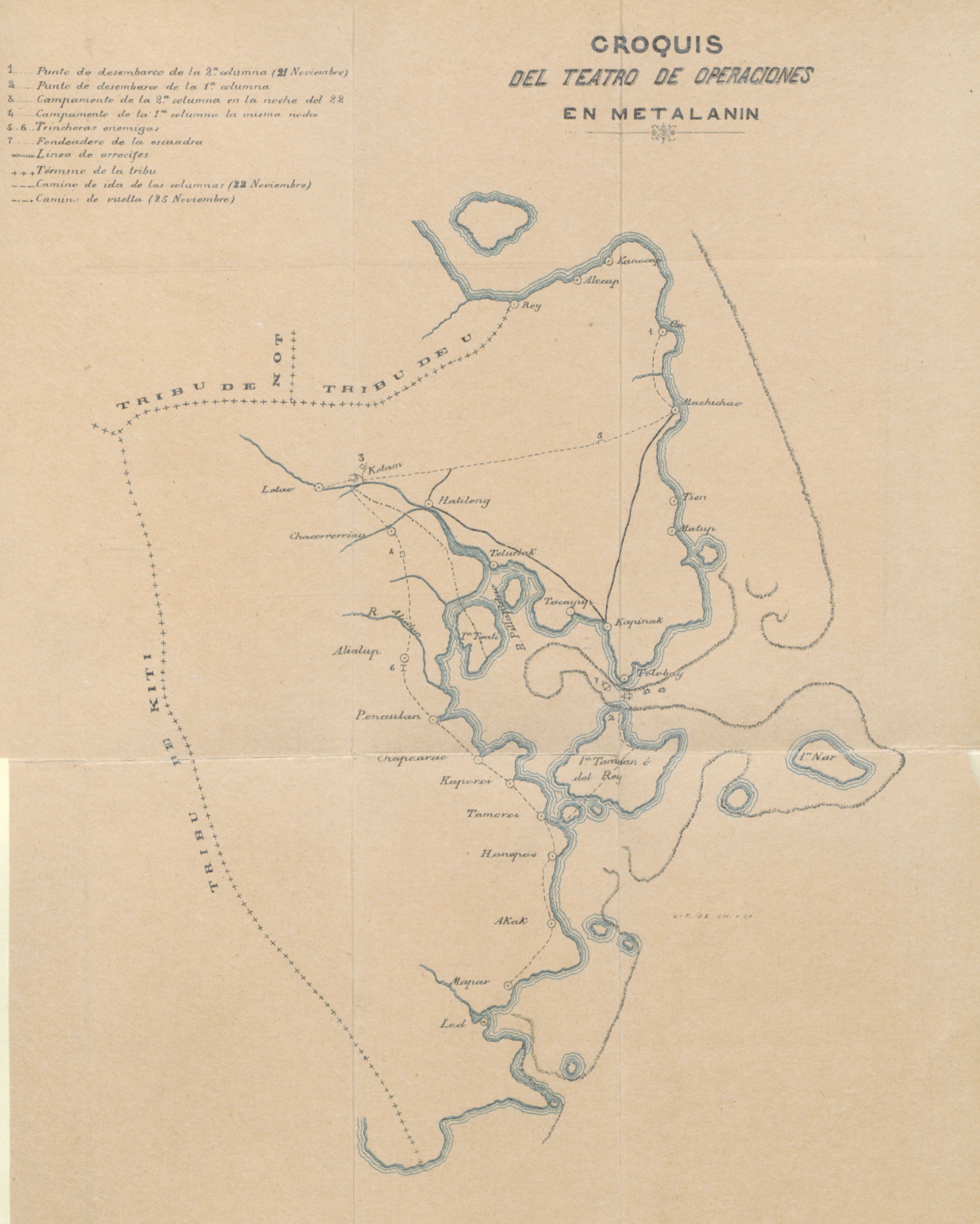
Image taken from page 313 of 'Estudios sobre Carolinas. La isla de Ponapé. Geografia, etnografia, historia ... Con un prólogo del ... Teniente General D. Valeriano Weyler. [With maps and plans.]'
nasa japan earthquake tsunami quake pacificocean sendal
GOES-11 Satellite Sees Pacific Ocean Basin After Japan Quake
oroluk pohnpei micronesia nikon d810 state
Wide View on Oroluk
zoo colorado denver kingfisher denverzoo micronesiankingfisher guamkingfisher todiramphuscinnamominuscinnamominus todiramphuscinnamominus paulfernandez kingfishermicronesian kingfisherguam
Micronesian Kingfisher at the Denver Zoo, Colorado
forest island rainforest scenery cloudforest tropics micronesia pohnpei ponape
View from Nan Aloud (Ngihneni), the highest point on Pohnpei, Micronesia
fsm micronesia pohnpei
Pohnpei Harbor
fsm papuanewguinea vanuatu tolley timorleste federatedstatesofmicronesia usscleveland 1ctcs pacificpartnership
110703-F-HS649-1477.jpg
bldigital date1895 pubplacemanila publicdomain sysnum000562483 cabezapereiroanacleto large vol0 page71 mechanicalcurator imagesfrombook000562483 imagesfromvolume0005624830 map rotated wp:bookspage=australiaandnewzealand georefphase2 sherlocknet:tag=land sherlocknet:tag=army sherlocknet:tag=slope sherlocknet:tag=march sherlocknet:tag=island sherlocknet:tag=general sherlocknet:tag=mile sherlocknet:tag=battle sherlocknet:tag=high sherlocknet:tag=light sherlocknet:tag=troop sherlocknet:tag=success sherlocknet:tag=british sherlocknet:tag=river sherlocknet:tag=state sherlocknet:tag=whole sherlocknet:tag=european sherlocknet:tag=regiment sherlocknet:category=maps hasgeoref geo:osmscale=14 geo:continent=australasia geo:country=fm geo:country=federatedstatesofmicronesia geo:state=pohnpei geo:city=madolenihmw geo:road=mandroad
Image taken from page 71 of 'Estudios sobre Carolinas. La isla de Ponapé. Geografia, etnografia, historia ... Con un prólogo del ... Teniente General D. Valeriano Weyler. [With maps and plans.]'
island airport fsm micronesia pohnpei
Pohnpei Airport Island
micronesia pohnpei nikon d810 nan madol nanmadol pacificocean pacific nikond810
White Clouds above Nan Madol
travel tree green water pool rock canon waterfall rocks foliage palmtrees micronesia waterscape oceania pohnpei travelphotography canonphotography federatedstatesofmicronesia kepirohiwaterfall kepirohi canon7d aprilmoulton
Kepirohi Waterfall
coast fsm states southeast micronesia federated pohnpei
On Pohnpei, Federated States of Micronesia
ocean white green nature water beautiful topv111 landscape island waterfall pond natural pacific fresh exotic tropical fsm micronesia swimm pohnpei firsttheearth worldwaterfallssurvey southpacificmicronesia
FSM - Beautiful Pohnpei
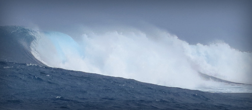
ocean travel blue sea seascape nature water canon surf waves power wave spray pointandshoot nationalgeographic canonpowershot micronesia waterscape compactcamera oceania pohnpei travelphotography roughsea canons100 roughocean canonphotography federatedstatesofmicronesia pointandshootcamera canonpowershots100 aprilmoulton
The Wave
ocean trees landscape paradise day cloudy jungle fsm fm micronesia oceania pohnpei federatedstatesofmicronesia
Palikir Landscape
micronesia pohnpei nanmadol federatedstatesofmicronesia
Nan Madol
ocean travel sea sky cloud seascape nature water rock clouds canon landscape island islands boat sailing exploring rope explore land sail pointandshoot mast synergy nationalgeographic canonpowershot micronesia waterscape worldtravel oceania sailingboat pohnpei travelphotography sailingvessel canons100 canonphotography federatedstatesofmicronesia pointandshootcamera canonpowershots100 aprilmoulton
Homeward Bound
polynesia pacific bikini ostfriesland samoa honolulu cookislands tahiti truk kwajalein guam kiribati tonga oldenburg borabora moorea micronesia yap papeete tarawa emsland majuro niue apia pohnpei aitutaki pazifik nauru chuuk tutuila pagopago südsee tuamotu akaiami fidschi upolu marquesas tokelau ponape nanmadol tubuai rotuma tuvalu haapai funafuti polynesien börger moala lakeba saterland johnstonatoll temwen hümmling ramsloh wschmitz
Moorea, Tahiti
ocean above coral plane island islands pacific flight aerial atoll federatedstatesofmicronesia continentalairmicronesia
Kosrae, Micronesia
fiji hawaii polynesia pacific leer vitilevu suva insel ostfriesland samoa honolulu cookislands rarotonga tahiti truk kwajalein palau guam kiribati tonga oldenburg borabora moorea atoll micronesia yap papeete tarawa emsland borkum majuro niue apia pohnpei aitutaki schmitz manihiki pazifik nauru savaii chuuk tutuila pagopago fidschi upolu tokelau atiu ponape nanmadol tubuai rotuma tuvalu funafuti polynesien börger saterland johnstonatoll ramsloh wschmitz mashallislands
Pacific Atoll
pohnpei kolonia micronesia federated states state turquoise water ocean pacific nikon d810
Rocks and Turquoise
ocean plane island airport pacific flight pohnpei federatedstatesofmicronesia continentalairmicronesia
Pohnpei Airport, Micronesia
ocean travel blue trees sea tree green nature grass forest canon landscape island islands airport raw scenic foliage runway coralreef micronesia waterscape oceania pohnpei travelphotography rawphotography canonphotography federatedstatesofmicronesia canon7d pohnpeiairport aprilmoulton
Pohnpei Airport
Ant Atoll, Pohnpei, Federated States of Micronesia
above sky coral clouds plane island islands turquoise air flight wing aerial marshall kwajalein atoll micronesia islandspacificoceancontinental
Kwajalein Atoll, Marshall Islands
areca micronesia pohnpei arecaceae agroforestry arecacatechu
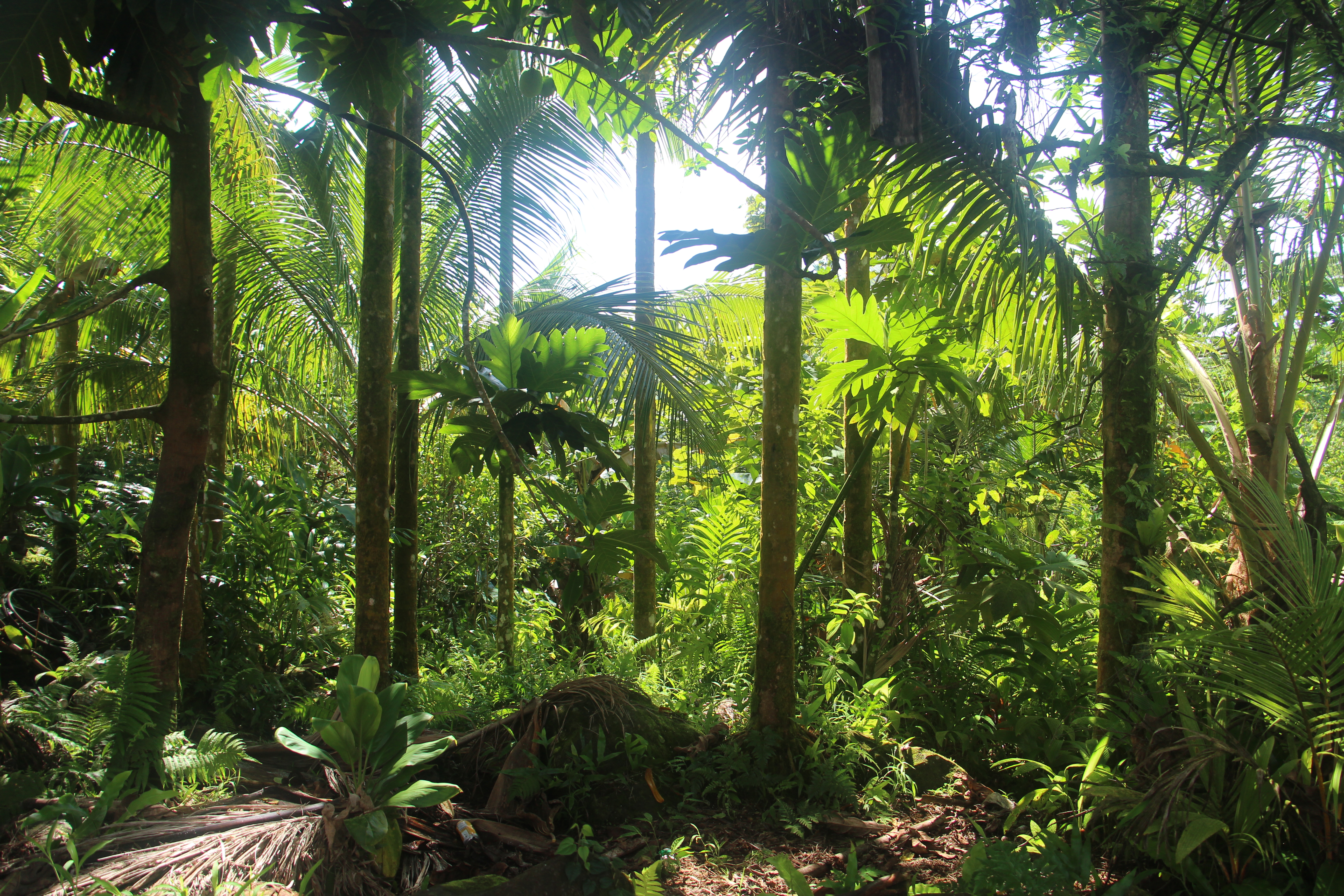
Pohnpei agroforest: betel nut and coconut
atol pacific sea lagoon clouds eos 550d canon island sky blue pohnpei
Atol from the sky
An Island in the Reef
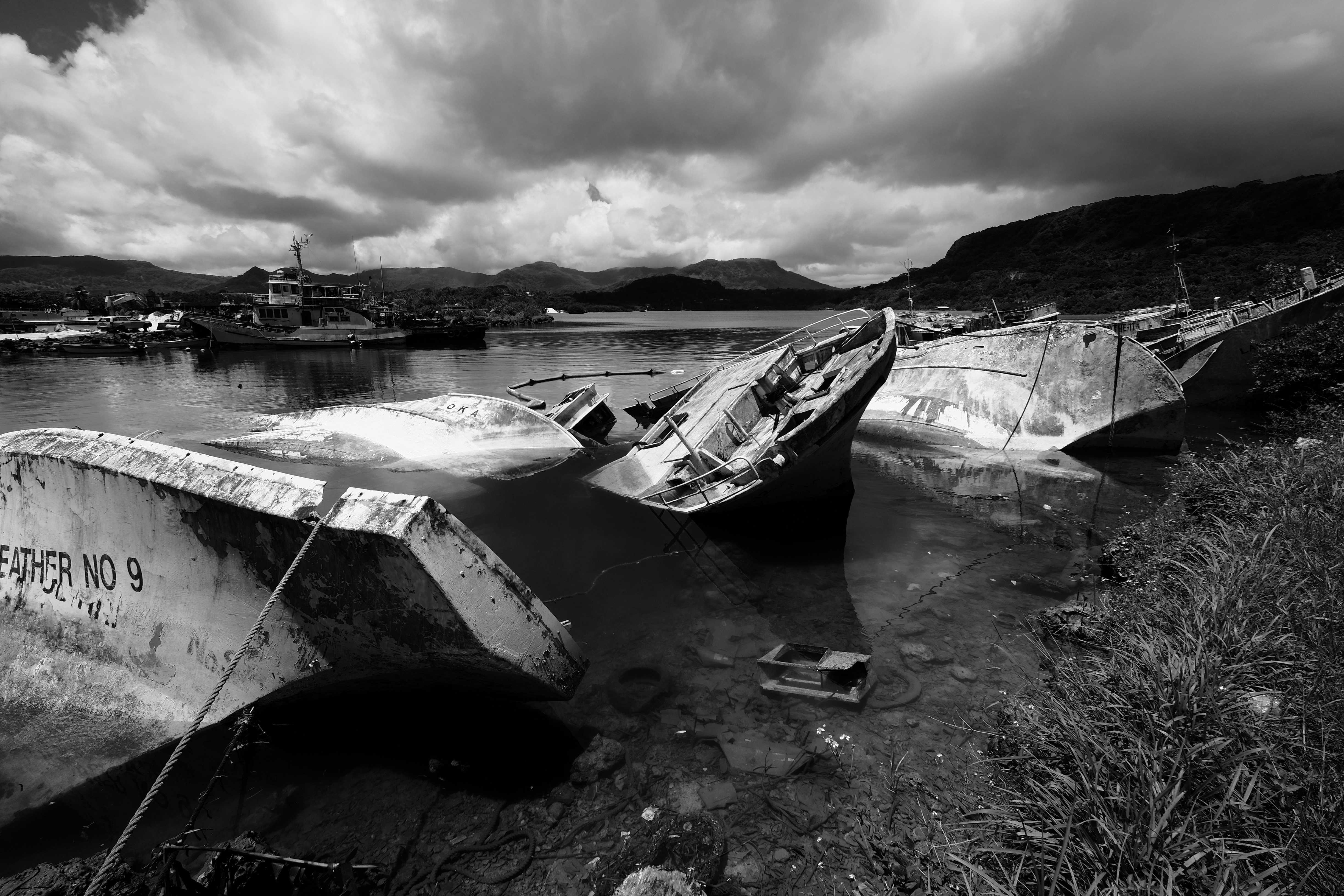
ship fsm micronesia pohnpei
sunken ships
micronesia pohnpei palikir unnamedroad
Pwusehn Malek ("Chickenshit Mountain"), Pohnpei