Elevation of Gajwel, Telangana, India
Location: India > Telangana > Medak >
Longitude: 78.681832
Latitude: 17.8451586
Elevation: 574m / 1883feet
Barometric Pressure: 95KPa
Elevation Map:
Satellite Map:
Related Photos:
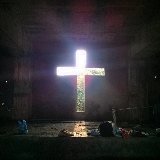
My uncle is the director of a school in Hyderabad which takes in orphans and children from broken homes. A chapel is being built so the children have a place to pray instead of underneath the scorching sun.
Topographic Map of Gajwel, Telangana, India
Find elevation by address:

Places near Gajwel, Telangana, India:
Konda Pochamma Sagar Reservoir
Thoguta
Ravelli
Mirdoddi
Ravalkole
Chegunta
Medchal
Shankarampet (r)
Shivampet
Dubbak
Lakadwala Colony
Ramayampet
7-136/2
Annaram
Tirupati Balaji Temple, Venkateshwara Nagar
Mallapur
Gajularamaram
Vani Nagar
Mahendra Hills
Siva Arun Colony
Recent Searches:
- Elevation of Corso Fratelli Cairoli, 35, Macerata MC, Italy
- Elevation of Tallevast Rd, Sarasota, FL, USA
- Elevation of 4th St E, Sonoma, CA, USA
- Elevation of Black Hollow Rd, Pennsdale, PA, USA
- Elevation of Oakland Ave, Williamsport, PA, USA
- Elevation of Pedrógão Grande, Portugal
- Elevation of Klee Dr, Martinsburg, WV, USA
- Elevation of Via Roma, Pieranica CR, Italy
- Elevation of Tavkvetili Mountain, Georgia
- Elevation of Hartfords Bluff Cir, Mt Pleasant, SC, USA