Elevation map of Amu Darya

Longitude: 62.3931108

Latitude: 40.3217364

Elevation: 152m / 499feet

Barometric Pressure: 100KPa

Elevation Map:

elevation map of Amu Darya

Satellite Map:

Satellite map of Amu Darya

Related Photos:

uzbekistan turkmenistan road highway frontier khiva bukhara amoriver amudarya oxus amudaryo амударё ەمۇدەريا‎ ὦξοσ türkmenistan ўзбекистон oʻzbekiston узбекистан
Frontier with Turkmenistan, from Uzbekistan Side
img7117 uzbekistan turkmenistan amudarya آمودریا amudaryo амударё amyderýa amu river amuriver 阿姆河 ouzbekistan узбекистан oezbekistan geo:lat=4144895183058737 geo:lon=6114087300390622 geotagged day clouds cloudy sunny
View over the river Amu Darya from Uzbekistan towards Turkmenistan
philosopher stone heaven sky cloud club eden edenpalm marrrakesh marrakech hughessonge bernawyflickr brunocouratier couratier songe hughes bruno bernawy flickr architect photographer dream gardens perpetual residence shaitan paradise جنّة‎ فردوس jannah adam hawwa salvation afterlife boundary saihan syrdarya jaihan amudarya furat euphrates nil nile rivers camphor esotericism metaphorical muhkamat mutashabihat inner meaning تأويل مصطلح التأويل الإسلامي الحديث صلى الله عليه وسلم والنفخ في الصور جامع البيان آي القرآن التفسير الدلالة chaharbagh garden exuberant foliage powerfully
بہشت کے آٹھ درجے جنت تأويل.....Garden of Eden....Gardens of Perpetual Residence...The highest level is known as firdaws (sometimes called Eden) or Illiyin.Gate of Esoteric interpretation
tajikistan horog khorog badakhshan gornobadakhshan panj amudarya centralasia afghanistan khorugh pamir pamirhighway silkroad road mountainroad mountain badakhsan
Gorno-Badakhshan, Tajikistan
tajikistan afghanistan wakhan wakhancorridor pamir hindukush mountains river panj panjriver amudarya silkroad namadgut khaakha kaakha badakhshan badakhsan
Wakhan, Tajikistan
afghanistan asia border tajikistan mountainous peaks snow river valley agriculture summer scree rocks steep remote rugged landscape water eriagn ngairehart ngairelawson pamirhighway silkroad traderoute trade historical noroads track panjriver amudarya glacier centralasia continent country mountain mountainrange pamirrange mudbrick subsistence cultivation silt geology terrain topography frontier strata tones pyanj
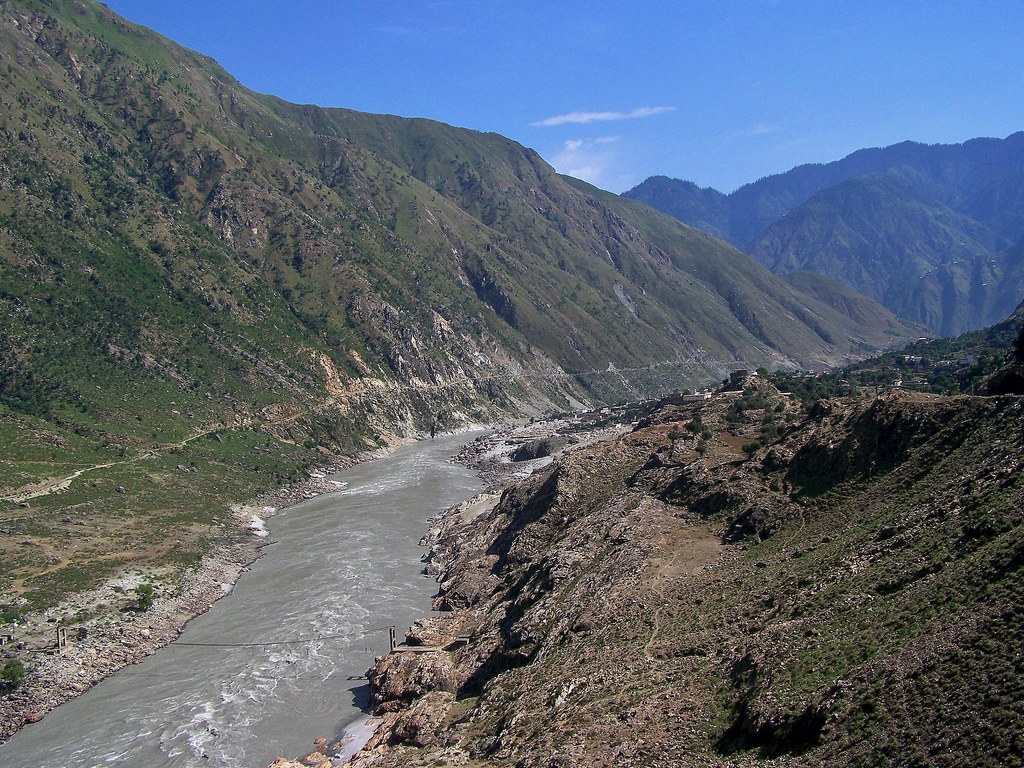
Panj River Dividing the Afghanistan Tajikistan Borders Asia
afghanistan tajikistan panj panjriver border mountains amudarya tourism silkroad pamir pamirhighway road mountainroad badakhsan badakhshan
View to Afghanistan from Tajikistan
plants building tree home nature water ecology architecture river outside outdoors community scenery asia outdoor structures architectural valley land environment tajikistan tajik residence centralasia environmentalism ecosystem riverbend edifice edifices hillsides residentialbuilding vakhshriver gharm surkhobriver regionofrepublicansubordination districtsofrepublicansubordination kyzylsuuriver rashtdistrict
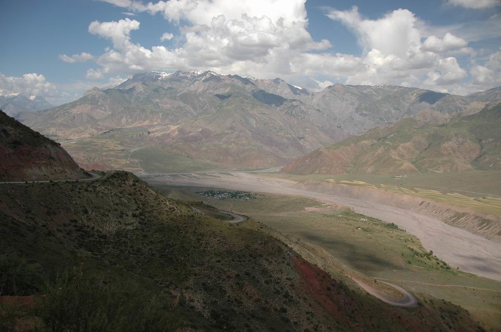
The town of Gharm in Tajikistan
aralsea satelliteimage
The Aral Sea, Central Asia
afghanistan tajikistan panj panjriver border mountains amudarya tourism silkroad pamir pamirhighway road mountainroad
View of Afghanistan from Tajikistan
afghanistan tajikistan panj panjriver border mountains amudarya tourism silkroad pamir pamirhighway road mountainroad
View of Afghanistan from Tajikistan
afghanistan tajikistan panj panjriver border mountains amudarya tourism silkroad pamir pamirhighway road mountainroad harvesting
View of Afghanistan from Tajikistan
tajikistan afghanistan wakhan wakhancorridor pamir hindukush mountains river panj panjriver amudarya silkroad kaakha khaakha namadgut badakhsan
Wakhan, Tajikistan
wakhan afghansitan badakhshan wakhannationalpark afghanistansfristnationalpartk nature snowleopar foxbrownbear ibex wildlife river mountin peace war yak women livelihood poverty community
A view of Afghanistan-Tajikstan vilige which is separated by a Panj River
bandeira asia flag uzbekistan oʻzbekiston uzbekistanflag ўзбекистон usbequistão oʻzbekistonflag flagofuzbekistan bandeiradouzbequistão
Oʻzbekiston / Ўзбекистон / Uzbekistan / Usbequistão
sts047-079-083
afghanistan river tajikistan centralasia 2009 oxus views100 amudaryariver badakhsan oxusriver worldtrekker kalaikhum tokalaikhum 20090618dsc5474
Oxus River Valley
bookcentury1900 bookdecade1900 bookyear1902 bookauthortolstoyleograf18281910 booksubjectsiberiarussiadescriptionandtravel booksubjecteasternquestioncentralasia booksubjectsovietuniondescriptionandtravel bookidallrussiastra00norm bookauthornormanhenry18581939 booksubjectcaucasusdescriptionandtravel booksubjectsovietunioneconomicconditions booksubjectfinlanddescriptionandtravel bookpublisherlondonheinemann bookcollectionamericana bookcontributoruniversityofcalifornialibraries booksponsormsn bookcollectioncdl bookleafnumber290
Image from page 290 of "All the Russias; travels and studies in contemporary European Russia, Finland, Siberia, the Caucasus, & Central Asia" (1902)
tajikistan horog khorog badakhshan gornobadakhshan panj amudarya centralasia afghanistan khorugh pamir pamirhighway silkroad hindukush road mountainroad mountain badakhsan
Gorno-Badakhshan, Tajikistan
nepal cloud river airplane nikon top flight holy kathmandu himalaya source arialphoto topview indus origin arial ganges birdview arialview brahmaputra holyriver photofromairplane kaosher creationofriver originofriver himalayanwatersource himalayanwaterflow
Origin of Creation
afghanistan asia border tajikistan mountainous peaks snow river valley agriculture summer scree rocks steep remote rugged landscape water eriagn ngairehart ngairelawson pamirhighway silkroad traderoute trade historical noroads track panjriver amudarya glacier centralasia continent country mountain mountainrange pamirrange mudbrick subsistence cultivation silt geology terrain topography frontier glacialvalley moraine riverbed
Mountainous Landscape Northern Afghanistan Asia
Caldera Roja Timanfaya, Lanzarote
silk road uzbekistan choresm history amu darya hdr kysylkum amo river canon dslr eos hdri spiegelreflexkamera slr
Urgench UZ - Amu Darya 03
tajikistan afghanistan wakhan wakhancorridor pamir hindukush mountains panj panjriver snow summit amudarya silkroad badakhsan
Wakhan, Tajikistan
tajikistan afghanistan wakhan wakhancorridor pamir hindukush mountains panj panjriver snow summit amudarya silkroad badakhsan
Wakhan, Tajikistan
badakhshan badahkshan afghanistan asia border tajikistan mountainous peaks snow river valley agriculture summer scree rocks steep remote rugged landscape water eriagn ngairehart ngairelawson pamirhighway silkroad traderoute trade historical noroads track panjriver amudarya glacier centralasia continent country mountain mountainrange pamirrange mudbrick subsistence cultivation silt geology terrain topography frontier earthslandscapes
Mountainous Landscape Northern Afghanistan Asia
pakistan mountains nature landscapes hills himalaya nwfp himalayas hazara upland karakoramhighway northwestfrontierprovince kohistan hindukush northpakistan mountainsinpakistan induskohistan amazingmountainlandscapes mountainouslandscapesinpakistan landscapesinpakistan landofthemountains کوہستان
The Indus River at District Kohistan, Pakistan - July 2009
nature water river natural indus waterbodies abasin indusriver riverindus deraismailkhan dikhan riversinpakistan riversofpakistan wetlandsofpakistan landscapesinpakistan deraismailkhandistrict nationalsymbolsofpakistan khyberpakhtunkhwa waterbodiesinpakistan naturalheritageofpakistan indusplains daryaisindh riverindusatderaismailkhan riverindusatdikhan thefatheroftherivers اباسين theindusriverinwinter theindusriverinfebruary deraismailkhaninwinter deraismailkhaninfebruary rigvedicrivers indusbasin landscapesinderaismailkhan landscapesinkhyberpakhtunkhwa abisindh breadbasketofpakistan pakistanslifeline
The Indus River at Dera Ismail Khan in Khyber Pakhtunkhwa, Pakistan - February 2011
nature river landscape areas northern northernareas indus potofgold indusriver administered federally northpakistan diamer theindusriver gilgitagency pakistanpakistanfananorthern pakistanmountainmountainous
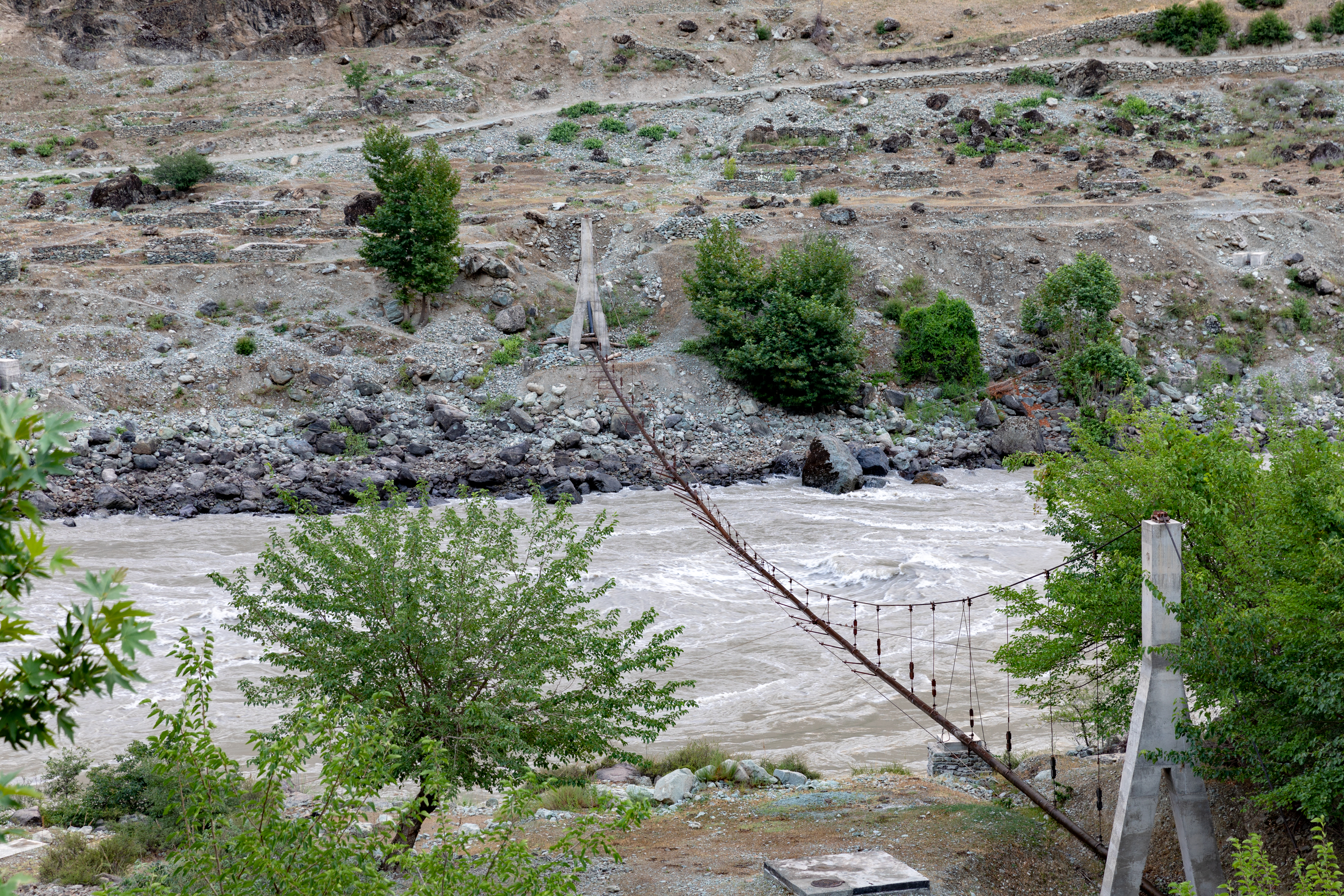
The Indus River at Diamer, Gilgit Agency, Pakistan - July 2009
pakistan mountains rivers nwfp indus indusriver riverindus northwestfrontierprovince attock nowshera noshera nizampur riversinpakistan pashtunareas pakhtunareas thelandofthepathans thepashtunlands abaseen
The Indus River at Attock, Pakistan - June 2006
bishkek kyrgazstan nature juniparnationalparkcentralasiaautumnforest
Ala Archa National Park
tajikistan horog khorog badakhshan gornobadakhshan panj amudarya centralasia afghanistan khorugh pamir pamirhighway silkroad hindukush road mountainroad mountain badakhsan
Gorno-Badakhshan, Tajikistan
pakistan nwfp indus indusriver swabi riversinpakistan sawabi zarobai zarobi wetlandinpakistan riversofpakistan earthasia gandgharpahar gangarpahar thelongestriverinpakistan
Gandghar Pahar with Indus in foreground, from Swabi, Pakistan - June 2006
tajikistan afghanistan wakhan wakhancorridor pamir hindukush mountains river panj panjriver amudarya silkroad badakhsan
Wakhan, Tajikistan