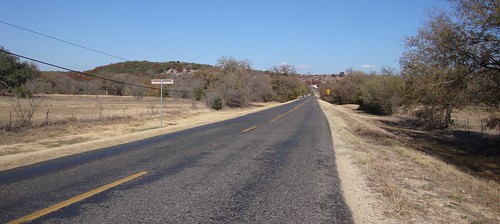
Elevation of FM, Bluff Dale, TX, USA
Location: United States > Texas > Erath County > Bluff Dale >
Longitude: -98.026358
Latitude: 32.2672731
Elevation: 340m / 1115feet
Barometric Pressure: 97KPa
Related Photos:
Topographic Map of FM, Bluff Dale, TX, USA
Find elevation by address:

Places near FM, Bluff Dale, TX, USA:
140 Autumn Valley
2184 Lakeside Dr
300 Lanyard Dr
12901 Bakers Crossing Rd
US-67, Stephenville, TX, USA
301 Co Rd 511
U.s. 377
5900 Hill City Hwy
437 S Belknap St
Stephenville
Hill City Hwy, Tolar, TX, USA
365 W Collins
FM, Hico, TX, USA
460 W Elm St
32083 N Fm 219
Tarleton State University
Farm To Market Road 914
Stephenville Medical & Surgical Clinic
Erath County
Comanche Peak Nuclear Power Plant
Recent Searches:
- Elevation of Gateway Blvd SE, Canton, OH, USA
- Elevation of East W.T. Harris Boulevard, E W.T. Harris Blvd, Charlotte, NC, USA
- Elevation of West Sugar Creek, Charlotte, NC, USA
- Elevation of Wayland, NY, USA
- Elevation of Steadfast Ct, Daphne, AL, USA
- Elevation of Lagasgasan, X+CQH, Tiaong, Quezon, Philippines
- Elevation of Rojo Ct, Atascadero, CA, USA
- Elevation of Flagstaff Drive, Flagstaff Dr, North Carolina, USA
- Elevation of Avery Ln, Lakeland, FL, USA
- Elevation of Woolwine, VA, USA


